Misplaced Pages

Random Article!

Chomo Lonzo

Article snapshot taken from Wikipedia with creative commons attribution-sharealike license. Give it a read and then ask your questions in the chat. We can research this topic together.
Mountain in Tibet, China
Chomo Lonzo
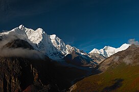
Chomo Lonzo (left), Lhotse and Mt. Everest (right)
Highest point
Elevation7,804 m (25,604 ft)
Ranked 24th
Prominence590 m (1,940 ft)
Parent peakMakalu
Listing
Coordinates27°55′47″N 87°06′26″E / 27.92981°N 87.10716°E / 27.92981; 87.10716
Geography
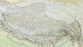
Chomo Lonzo is located in TibetChomo LonzoChomo Lonzo
About OpenStreetMapsMaps: terms of use 45km
30miles Nepal Pakistan ChinaNgadi Chuli South 45Ngadi Chuli SouthAnnapurna IV 42Annapurna IVHimalchuli West 41Himalchuli WestAnnapurna III 40Annapurna IIISilver Crag 37Silver CragAnnapurna Fang 36Annapurna FangDhaulagiri IV 35Dhaulagiri IVMolamenqing (Phola Gangchen) 34Molamenqing (Phola Gangchen)Hillary Peak (Ngojumba Kang III) 33Hillary Peak (Ngojumba Kang III)Gurla Mandhata (Naimona'nyi, Namu Nan) 32Gurla Mandhata (Naimona'nyi, Namu Nan)Dhaulagiri III 30Dhaulagiri IIINgojumba Kang II 29Ngojumba Kang IIDhaulagiri II 28Dhaulagiri IIKamet 27KametChomo Lonzo (Chomolonzo, Chomolönzo, Chomo Lönzo, Jomolönzo, Lhamalangcho) 24Chomo Lonzo (Chomolonzo, Chomolönzo, Chomo Lönzo, Jomolönzo, Lhamalangcho)Nanda Devi 23Nanda DeviNuptse (Nubtse) 22Nuptse (Nubtse)Ngadi Chuli (Peak 29, Dakura, Dakum, Dunapurna) 21Ngadi Chuli (Peak 29, Dakura, Dakum, Dunapurna)Himalchuli (Himal Chuli) 20Himalchuli (Himal Chuli)Tenzing Peak (Ngojumba Kang, Ngozumpa Kang, Ngojumba Ri) 18Tenzing Peak (Ngojumba Kang, Ngozumpa Kang, Ngojumba Ri)Annapurna II 17Annapurna IIGyachung Kang 16Gyachung KangAnnapurna I East (Annapurna East Peak) 15Annapurna I East (Annapurna East Peak)Manaslu East 14Manaslu EastShishapangma (Shishasbangma, Xixiabangma) 13Shishapangma (Shishasbangma, Xixiabangma)Annapurna 12AnnapurnaNanga Parbat (Diamer) 11Nanga Parbat (Diamer)Manaslu (Kutang) 10Manaslu (Kutang)Dhaulagiri 9DhaulagiriCho Oyu 8Cho OyuMakalu 5MakaluLhotse 3Lhotse Mount Everest 1Mount Everest  The major peaks (not mountains) above 7,500 m (24,600 ft) height in Himalayas, rank identified in Himalayas alone (not the world). The map may help give context to Chomo Lonzo with more detail and zooming on click through.

Legend:
1:Mount Everest,  2:Kangchenjunga,  3:Lhotse,  4:Yalung Kang, Kanchenjunga West,  5:Makalu,  6:Kangchenjunga South,  7:Kangchenjunga Central,  8:Cho Oyu,  9:Dhaulagiri,  10:Manaslu (Kutang),  11:Nanga Parbat (Diamer) ,  12:Annapurna,  13:Shishapangma (Shishasbangma, Xixiabangma),  14:Manaslu East,  15:Annapurna East Peak,  16: Gyachung Kang,  17:Annapurna II ,  18:Tenzing Peak (Ngojumba Kang, Ngozumpa Kang, Ngojumba Ri),  19:Kangbachen,  20:Himalchuli (Himal Chuli),  21:Ngadi Chuli (Peak 29, Dakura, Dakum, Dunapurna),  22:Nuptse (Nubtse),  23:Nanda Devi,  24:Chomo Lonzo (Chomolonzo, Chomolönzo, Chomo Lönzo, Jomolönzo, Lhamalangcho),  25:Namcha Barwa (Namchabarwa),  26:Zemu Kang (Zemu Gap Peak),  27:Kamet,  28:Dhaulagiri II,  29:Ngojumba Kang II,  30:Dhaulagiri III,  31:Kumbhakarna Mountain (Mount Kumbhakarna, Jannu),  32:Gurla Mandhata (Naimona'nyi, Namu Nan) ,  33:Hillary Peak (Ngojumba Kang III),  34:Molamenqing (Phola Gangchen),  35:Dhaulagiri IV,  36:Annapurna Fang,  37:Silver Crag,  38:Kangbachen Southwest,  39:Gangkhar Puensum (Gangkar Punsum),  40:Annapurna III,  41:Himalchuli West,  42:Annapurna IV,  43:Kula Kangri,  44:Liankang Kangri (Gangkhar Puensum North, Liangkang Kangri),  45:Ngadi Chuli South

 
CountryChina
RegionTibet
Parent rangeMahalangur Himal
Climbing
First ascent1954 by Jean Couzy and Lionel Terray
Easiest routeSnow/ice climb

Chomo Lonzo (Chinese: 珠穆隆索峰; pinyin: Zhūmùlóngsuǒ Fēng) is a mountain in Tibet, 5 km northeast of Makalu in the Mahalungur (Mohalingor) or Khumbu Himalayas. Alternate spellings of the same name include Chomolonzo, Chomolönzo, Chomo Lönzo, Jomolönzo, and Lhamalangcho.

Chomo-Lonzo has three distinct summits. The Southern, main peak (7804m) is joined via a ~ 7250m saddle to the Central peak (7565m), which is joined via a ~7050m saddle to a ~7200m North (or North West) peak.

While from Nepal the mountain is overpowered by nearby Makalu, the fifth-highest peak in the world, the three peaks are a very impressive and dominating sight from the Kangshung valley in Tibet. Chomo-Lonzo translates to “bird goddess” and from the East the mountain indeed brings to mind a 3 km high eagle with spread wings.

Climbing History

On October 30, 1954 the French climbers Jean Couzy and Lionel Terray made the first ascent of the main summit via the gently sloping SW ridge from the 7200m Sakietang La that separates Chomo Lonzo from Makalu. They did this as an afterthought during a reconnaissance expedition to the Makalu, which they first-ascended the next year. The second ascent was on October 24, 1993 by a Japanese expedition which found a route through the NW face that joined the SW ridge half-way. A third and currently last ascent of the main peak in 1994 followed the original SW ridge route. The Central and North peaks remained unclimbed until 2005.

In April 2005, a French expedition first explored the NE face but, finding it too challenging, approached the mountain from the West and Northwest instead. One team (Yannick Graziani, Christian Trommsdorff and Patrick Wagnon) climbed the North summit over the NW ridge on May 7, while another (Stéphane Benoist and Patrice Glairon-Rappaz) reached it over the West face on May 16. The first team reascended the North peak and continued to reach the central peak on May 21. The initial plan to traverse all three peaks and descend via the Sakietang La proved impossible.

View

Chomo LonzoMakaluEverestTibetan PlateauRong River (Tibet)ChangtseRongbuk GlacierNorth Face (Everest)East Rongbuk GlacierNorth Col north ridge routeLhotseNuptseSouth Col routeGyachung KangCho OyuFile:Himalaya annotated.jpg
Southern and northern climbing routes as seen from the International Space Station. (The names on the photo are links to corresponding pages.)

See also

References

  1. ^ "Topographic map of Chomo Lonzo". opentopomap.org. Retrieved 2023-11-10.
  2. "Chomo Lonzo". Peakbagger.com. Retrieved 2010-03-09.
  3. "Peak Bagger:Himalaya, Central Nepal Himalaya, Khumbu, Ghurka Himal, Annapurna Himal, Xishapangma Area, Sikkim-Eastern Nepal Himalaya, Western Nepal Himalaya, Assam Himalaya, Punjab Himalaya, Bhutan Himalaya, Garwhal Himalaya, Ganesh Himal". Retrieved 22 October 2024.
  4. ^ Franco (1957), pp. 31, 108.
  5. "Asia, Nepal, Makalu". American Alpine Journal. 10 (1). American Alpine Club. 1956. Retrieved 2023-11-10.
  6. "Asia, Tibet, Chomo Lönzo". American Alpine Journal. 36 (68). American Alpine Club. 1994. Retrieved 2023-11-10.
  7. "Asia, Nepal, Makalu, Kangchungtse and Chomo Lönzo". American Alpine Journal. 69 (37). American Alpine Club. 1995. Retrieved 2023-11-10.
  8. Graziani, Yannick (2006). "Chomo Lonzo". American Alpine Journal. 69 (37). Translated by Ware, Caroline. American Alpine Club. Retrieved 2023-11-10.
Sources

External links

Media related to Chomo Lonzo at Wikimedia Commons

Categories: