| This article needs additional citations for verification. Please help improve this article by adding citations to reliable sources. Unsourced material may be challenged and removed. Find sources: "A206 road" – news · newspapers · books · scholar · JSTOR (October 2022) (Learn how and when to remove this message) |
 A206
A206 | ||||
|---|---|---|---|---|
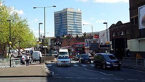
 Woolwich High Street forms part of the A206 Woolwich High Street forms part of the A206 | ||||
| Route information | ||||
| Length | 15 mi (24 km) | |||
| Major junctions | ||||
| West end | Greenwich | |||
| Major intersections | ||||
| East end | Greenhithe | |||
| Location | ||||
| Country | United Kingdom | |||
| Primary destinations | Greenwich, Woolwich, Plumstead, Dartford Crossing | |||
| Road network | ||||
| ||||
The A206 road is a road in southeast London and Kent, England.
Length
Today it is approximately 15 miles (24 km) in length, although the final section is a relatively new road.
Purpose of route
Its primary purpose is to link into the London Orbital motorway at the Dartford Crossing and is heavily used by lorries.
Route
It links Greenwich with Greenhithe following the line of the River Thames.
References
- "A282 J1A Littlebrook Interchange". roads.org.uk. Retrieved 5 September 2022.
External links
![]() Media related to A206 road (England) at Wikimedia Commons
Media related to A206 road (England) at Wikimedia Commons
| A roads in Zone 2 of the Great Britain road numbering scheme | ||
|---|---|---|
51°28′56″N 0°06′44″E / 51.48213°N 0.11235°E / 51.48213; 0.11235
This London road or road transport-related article is a stub. You can help Misplaced Pages by expanding it. |