| Acton | |
|---|---|
| Regional county municipality | |
 | |
| Coordinates: 45°39′N 72°34′W / 45.650°N 72.567°W / 45.650; -72.567 | |
| Country | |
| Province | |
| Region | Montérégie |
| Effective | January 1, 1982 |
| County seat | Acton Vale |
| Communities |
List
|
| Government | |
| • Type | Prefecture |
| • Prefect | Jean-Marie Laplante |
| Area | |
| • Total | 583.00 km (225.10 sq mi) |
| • Land | 579.80 km (223.86 sq mi) |
| Population | |
| • Total | 15,594 |
| • Density | 26.9/km (70/sq mi) |
| • Change 2011-2016 | |
| • Dwellings | 7,101 |
| Time zone | UTC−5 (EST) |
| • Summer (DST) | UTC−4 (EDT) |
| Area codes | 450 and 579 |
| Website | www |
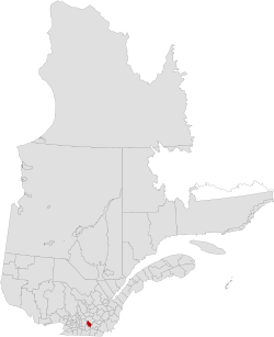
Acton Regional County Municipality is a regional county municipality located in the Montérégie region of Quebec. The seat is Acton Vale.
Founded in 1982, the Acton Regional County Municipality is made up of eight smaller municipalities containing a little fewer than 16,000 people. The average population density is 26.9 per square kilometre. About half of the population is concentrated in the town of Acton Vale.
Subdivisions
There are 8 subdivisions within the RCM:
|
|
|
|
|
Demographics
Mother tongue from Canada 2016 Census
| Language | Population | Pct (%) |
|---|---|---|
| French only | 14,925 | 95.7% |
| English only | 160 | 1.0% |
| Both English and French | 55 | 0.4% |
| Other languages | 455 | 2.9% |
Transportation
Access Routes
Highways and numbered routes that run through the municipality, including external routes that start or finish at the county border:
|
|
Attractions and Other Areas
La Campagnarde Trail
See also
References
- "Banque de noms de lieux du Québec: Reference number 141124". toponymie.gouv.qc.ca (in French). Commission de toponymie du Québec.
- ^ "Répertoire des municipalités: Geographic code 480". www.mamh.gouv.qc.ca (in French). Ministère des Affaires municipales et de l'Habitation.
- ^ "Census Profile, 2016 Census Acton, Municipalité régionale de comté [Census division], Quebec". Statistics Canada. Retrieved November 25, 2019.
- "Acton Regional County Municipality (Code 2448) Census Profile". 2011 census. Government of Canada - Statistics Canada.
- Acton RCM Archived March 24, 2009, at the Wayback Machine
- Official Transport Quebec Road Map
External links
| Adjacent Counties & Equivalent Territories | ||||||||||||||||
|---|---|---|---|---|---|---|---|---|---|---|---|---|---|---|---|---|
| ||||||||||||||||