| Agger | |
|---|---|
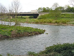
 The confluence of the Sülz and Agger Rivers near Lohmar The confluence of the Sülz and Agger Rivers near Lohmar | |
| Location | |
| Country | Germany |
| State | North Rhine-Westphalia |
| Physical characteristics | |
| Source | |
| • location | Sauerland |
| Mouth | |
| • location | Sieg |
| • coordinates | 50°48′2″N 7°10′27″E / 50.80056°N 7.17417°E / 50.80056; 7.17417 |
| Length | 69.5 km (43.2 mi) |
| Basin size | 816 km (315 sq mi) |
| Basin features | |
| Progression | Sieg→ Rhine→ North Sea |
| Tributaries | |
| • left | Wiehl, Naafbach |
| • right | Leppe, Sülz |
The Agger is a river in Germany, a right tributary of the Sieg in North Rhine-Westphalia. It is 69.5 kilometres (43.2 mi) long. Its source is in the Sauerland hills, near Meinerzhagen. It winds through the towns Engelskirchen, Overath and Lohmar. Near Siegburg the Agger flows into the Sieg.
Tributaries
The following rivers are tributaries to the river Agger (from source to mouth):
- Left: Rengse, Dörspe, Steinagger, Halstenbach, Wiehl, Kaltenbach, Loopebach, Schlingenbach, Lombach, Hohner Bach, Naafbach, Jabach, Auelsbach, Rothenbach
- Right: Genkel, Seßmarbach, Rospebach, Strombach, Loper Bach, Walbach, Leppe, Oberscheider Bach, Sülz
See also
References
- ^ Hydrographic Directory of the NRW State Office for Nature, the Environment and Consumer Protection (Gewässerverzeichnis des Landesamtes für Natur, Umwelt und Verbraucherschutz NRW 2010) (xls; 4.67 MB)
This article related to a river in North Rhine-Westphalia is a stub. You can help Misplaced Pages by expanding it. |