This article is about the city in Georgia. For the choreographer, see Alvin Ailey. For the film, see Ailey (film). City in Georgia, United States
| Ailey, Georgia | |
|---|---|
| City | |
 Ailey City Hall Ailey City Hall | |
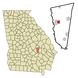
 Location in Montgomery County and the state of Georgia Location in Montgomery County and the state of Georgia | |
| Coordinates: 32°11′14″N 82°34′8″W / 32.18722°N 82.56889°W / 32.18722; -82.56889 | |
| Country | United States |
| State | Georgia |
| County | Montgomery |
| Area | |
| • Total | 2.18 sq mi (5.64 km) |
| • Land | 2.16 sq mi (5.59 km) |
| • Water | 0.02 sq mi (0.05 km) |
| Elevation | 249 ft (76 m) |
| Population | |
| • Total | 519 |
| • Density | 240.39/sq mi (92.82/km) |
| Time zone | UTC-5 (Eastern (EST)) |
| • Summer (DST) | UTC-4 (EDT) |
| ZIP code | 30410 |
| Area code | 912 |
| FIPS code | 13-00828 |
| GNIS feature ID | 0310413 |
Ailey is a city in Montgomery County, Georgia, United States. As of the 2020 census, the city had a population of 519, up from 432 in 2010.
History
A post office called Ailey was established in 1891. The town incorporated in 1893.
Geography
Ailey is located in western Montgomery County at 32°11′14″N 82°34′8″W / 32.18722°N 82.56889°W / 32.18722; -82.56889 (32.187181, -82.568932). It is bordered to the west by Mount Vernon, the county seat. U.S. Route 280 passes through Ailey, leading west through Mount Vernon 23 miles (37 km) to McRae–Helena and east 10 miles (16 km) to Vidalia.
According to the United States Census Bureau, the city of Ailey has a total area of 2.2 square miles (5.7 km), of which 0.02 square miles (0.05 km), or 0.92%, are water. The city is drained by tributaries of the Oconee River.
Climate
| Climate data for Ailey, Georgia | |||||||||||||
|---|---|---|---|---|---|---|---|---|---|---|---|---|---|
| Month | Jan | Feb | Mar | Apr | May | Jun | Jul | Aug | Sep | Oct | Nov | Dec | Year |
| Mean daily maximum °F (°C) | 60.4 (15.8) |
64.3 (17.9) |
70.7 (21.5) |
78.6 (25.9) |
85.6 (29.8) |
90.7 (32.6) |
92.7 (33.7) |
91.6 (33.1) |
87.0 (30.6) |
79.5 (26.4) |
70.3 (21.3) |
62.9 (17.2) |
77.9 (25.5) |
| Mean daily minimum °F (°C) | 37.1 (2.8) |
38.9 (3.8) |
44.3 (6.8) |
52.4 (11.3) |
60.3 (15.7) |
66.5 (19.2) |
69.8 (21.0) |
69.3 (20.7) |
64.5 (18.1) |
54.2 (12.3) |
44.4 (6.9) |
38.6 (3.7) |
53.4 (11.9) |
| Average precipitation inches (mm) | 4.4 (110) |
4.2 (110) |
4.7 (120) |
3.2 (81) |
3.8 (97) |
4.2 (110) |
4.8 (120) |
5.4 (140) |
3.6 (91) |
2.4 (61) |
2.5 (64) |
3.5 (89) |
46.5 (1,180) |
| Source: Weatherbase | |||||||||||||
Demographics
| Census | Pop. | Note | %± |
|---|---|---|---|
| 1900 | 271 | — | |
| 1910 | 306 | 12.9% | |
| 1920 | 385 | 25.8% | |
| 1930 | 428 | 11.2% | |
| 1940 | 506 | 18.2% | |
| 1950 | 508 | 0.4% | |
| 1960 | 469 | −7.7% | |
| 1970 | 487 | 3.8% | |
| 1980 | 579 | 18.9% | |
| 1990 | 579 | 0.0% | |
| 2000 | 394 | −32.0% | |
| 2010 | 432 | 9.6% | |
| 2020 | 519 | 20.1% | |
| U.S. Decennial Census 1850-1870 1880 1890-1910 1920-1930 1930-1940 1940-1950 1960-19801980-2000 | |||
In 2020, the city had a resident population of 519.
Notable people
- Hugh Peterson, lawyer
- Sugar Ray Robinson, boxer
References
- ^ "2022 U.S. Gazetteer Files: Georgia". United States Census Bureau. Retrieved January 27, 2023.
- ^ "P1. Race – Ailey city, Georgia: 2020 DEC Redistricting Data (PL 94-171)". U.S. Census Bureau. Retrieved January 27, 2023.
- "U.S. Census website". United States Census Bureau. Retrieved January 31, 2008.
- "US Board on Geographic Names". United States Geological Survey. October 25, 2007. Retrieved January 31, 2008.
- "County". Jim Forte Postal History. Retrieved September 6, 2017.
- Candler, Allen Daniel; Evans, Clement Anselm (1906). Georgia: Comprising Sketches of Counties, Towns, Events, Institutions, and Persons. State historical association. p. 32.
- "US Gazetteer files: 2010, 2000, and 1990". United States Census Bureau. February 12, 2011. Retrieved April 23, 2011.
- "Weatherbase: Historical Weather for Ailey, Georgia". Weatherbase. 2011. Retrieved on November 24, 2011.
- "Decennial Census of Population and Housing by Decades". US Census Bureau.
- "1870 Census of Population - Georgia" (PDF). US Census Bureau. 1870.
- "1880 Census of Population - Georgia" (PDF). US Census Bureau. 1880.
- "1910 Census of Population - Georgia" (PDF). US Census Bureau. 1930.
- "1930 Census of Population - Georgia" (PDF). US Census Bureau. 1930. p. 253.
- "1940 Census of Population - Georgia" (PDF). US Census Bureau. 1940.
- "1950 Census of Population - Georgia" (PDF). US Census Bureau. 1980.
- "1980 Census of Population - Number of Inhabitants - Georgia" (PDF). US Census Bureau. 1980.
- "2000 Census of Population - General Population Characteristics - Georgia" (PDF). US Census Bureau. 2000.
| Municipalities and communities of Montgomery County, Georgia, United States | ||
|---|---|---|
| County seat: Mount Vernon | ||
| Cities |  | |
| Towns | ||
| Unincorporated communities | ||
| Footnotes | ‡This populated place also has portions in an adjacent county or counties | |