| This article needs additional citations for verification. Please help improve this article by adding citations to reliable sources. Unsourced material may be challenged and removed. Find sources: "Akranes" – news · newspapers · books · scholar · JSTOR (July 2019) (Learn how and when to remove this message) |
| Akraneskaupstaður | |
|---|---|
| Municipality | |
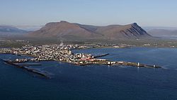
 July 2008 aerial view of Akranes. July 2008 aerial view of Akranes. | |
 Coat of arms Coat of arms | |
 Location of the municipality Location of the municipality | |
 | |
| Coordinates: 64°18′57″N 22°05′41″W / 64.3158059°N 22.09466°W / 64.3158059; -22.09466 | |
| Country | Iceland |
| Region | Western Region |
| Constituency | Northwest Constituency |
| Government | |
| • Mayor | Haraldur Benediktsson |
| Area | |
| • Total | 9 km (3 sq mi) |
| Population | |
| • Total | 8,452 |
| • Density | 823.44/km (2,132.7/sq mi) |
| Postal code(s) | 300, 301, 302 |
| Municipal number | 3000 |
| Website | akranes |

Akranes (Icelandic pronunciation: [ˈaːkraˌnɛːs] ) is a port town and municipality on the west coast of Iceland, around 50 km (31 mi) north of the capital Reykjavík.
The area where Akranes is located was settled in the 9th century; however, it did not receive a municipal charter until 1942.
History
Akranes was settled in the 9th century by the brothers Þormóður and Ketill, sons of Bresi, who came from Ireland. The town started to form in the mid-17th century as a fishing village. In 1942, it was formally chartered, and in the following years it had the biggest surge in population in its history.
Industry has been a big and growing employer: a cement plant has been operated in the town since the 1950s, and an aluminium smelting plant has been in operation near the town since 1998.
Economy
The fishing industry remains the town's most important source of employment. Akranes also acts as a service center for the large rural region surrounding it.
The town is expected to grow in the coming years because of an increase in industrial activity and improvements in transportation to the Reykjavík area. The 5.57 km-long (3.46 mi) Hvalfjörður Tunnel, opened in 1998, is one of the world's longest underwater road tunnels.
Notable people
Akranes was the birthplace of the Atom poet Jón Óskar, the writer Eva Björg Ægisdóttir and footballers Ríkharður Jónsson and Arnór Sigurðsson.
Sport
Akranes has a strong football tradition. The local team, Íþróttabandalag Akraness (ÍA), which currently plays in the Úrvalsdeild karla, has for many years been among the best of the Icelandic football league system. Ríkharður Jónsson, who was born in the town, is often considered to be one of Iceland's finest footballers. He both played for and managed ÍA. Former Sheffield Wednesday and Arsenal midfielder Siggi Jónsson was also born in Akranes and had three seasons as a player with ÍA. The town is also home to second division club Knattspyrnufélagið Kári.
Climate
Akranes has a subarctic climate (Köppen: Dfc; Trewartha: Eolo), with temperatures rising above 10 °C (50 °F) only in July and August.
| Climate data for Akranes, 1961–1990 normals, extremes 1965–1987 | |||||||||||||
|---|---|---|---|---|---|---|---|---|---|---|---|---|---|
| Month | Jan | Feb | Mar | Apr | May | Jun | Jul | Aug | Sep | Oct | Nov | Dec | Year |
| Record high °C (°F) | 10.0 (50.0) |
9.0 (48.2) |
9.9 (49.8) |
13.9 (57.0) |
16.9 (62.4) |
17.9 (64.2) |
24.1 (75.4) |
21.3 (70.3) |
19.4 (66.9) |
14.5 (58.1) |
12.2 (54.0) |
10.7 (51.3) |
24.1 (75.4) |
| Mean daily maximum °C (°F) | 2.2 (36.0) |
2.7 (36.9) |
2.9 (37.2) |
5.4 (41.7) |
8.8 (47.8) |
11.4 (52.5) |
13.0 (55.4) |
12.7 (54.9) |
10.0 (50.0) |
6.9 (44.4) |
3.6 (38.5) |
2.3 (36.1) |
6.8 (44.2) |
| Daily mean °C (°F) | −0.2 (31.6) |
0.5 (32.9) |
0.6 (33.1) |
3.0 (37.4) |
5.9 (42.6) |
8.8 (47.8) |
10.4 (50.7) |
10.1 (50.2) |
7.6 (45.7) |
4.7 (40.5) |
1.3 (34.3) |
0.1 (32.2) |
4.4 (39.9) |
| Mean daily minimum °C (°F) | −2.8 (27.0) |
−2.1 (28.2) |
−2.1 (28.2) |
0.5 (32.9) |
3.3 (37.9) |
6.6 (43.9) |
8.1 (46.6) |
7.8 (46.0) |
5.0 (41.0) |
2.2 (36.0) |
−1.3 (29.7) |
−2.5 (27.5) |
1.9 (35.4) |
| Record low °C (°F) | −20.0 (−4.0) |
−17.6 (0.3) |
−18.0 (−0.4) |
−18.0 (−0.4) |
−7.7 (18.1) |
−0.4 (31.3) |
2.5 (36.5) |
−1.2 (29.8) |
−3.6 (25.5) |
−10.7 (12.7) |
−11.8 (10.8) |
−17.1 (1.2) |
−20.0 (−4.0) |
| Average precipitation mm (inches) | 67.2 (2.65) |
74.5 (2.93) |
76.6 (3.02) |
70.9 (2.79) |
44.6 (1.76) |
56.8 (2.24) |
54.0 (2.13) |
85.7 (3.37) |
72.6 (2.86) |
95.4 (3.76) |
85.3 (3.36) |
81.7 (3.22) |
865.3 (34.07) |
| Source: Icelandic Meteorological Office | |||||||||||||
Twin towns – sister cities
See also: List of twin towns and sister cities in IcelandAkranes is twinned with:
 Bamble, Norway
 Närpes, Finland
 Qaqortoq, Greenland
 Sørvágur, Faroe Islands
 Tønder, Denmark
 Västervik, Sweden
See also
Gallery
-
Akranes harbour
-
Akrafjall, located nearby
-
Straw bales near Akranes
-
Old lighthouse of Akranes
-
New lighthouse of Akranes
References
- "Population by municipalities, sex and age 1 January 1998-2019 - Current municipalities". PX-Web. Retrieved 7 April 2019.
- "Mánaðarmeðaltöl fyrir stöð 95 - Akranes" (in Icelandic). Icelandic Meteorological Office. Archived from the original on 2024-11-17. Retrieved 17 November 2024.
- "Vinabæir Akraness". akranes.is (in Icelandic). Akranes. Retrieved 2020-02-12.
External links
- Official website
 (in Icelandic)
| Municipalities of Iceland | |
|---|---|
| Capital Region | |
| Southern Peninsula | |
| Western Region | |
| Westfjords | |
| Northwestern Region | |
| Northeastern Region | |
| Eastern Region | |
| Southern Region | |
This Iceland location article is a stub. You can help Misplaced Pages by expanding it. |
