| Al-ʽArish العريش | |
|---|---|
| Abandoned village | |
 | |
 | |
| Coordinates: 26°3′3″N 51°3′24″E / 26.05083°N 51.05667°E / 26.05083; 51.05667 | |
| Country | |
| Municipality | Ash Shamal |
| Zone | Zone 78 |
| District no. | 393 |
| Area | |
| • Total | 5.5 sq mi (14.2 km) |
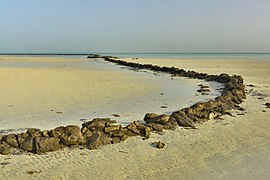
Al-ʽArish (Arabic: العريش) is an abandoned village in Qatar, located in the municipality of Ash Shamal. It lies one mile south-west of the coastal village of Al Khuwayr.
Etymology
Arish, an Arabic term, refers to palm trees; it was named so after palm trees growing in the area which shaded the entire village.
History
Al Arish was among the villages occupied by Abdullah bin Jassim Al Thani's forces in July 1937 during his military expedition against the Alkubaisi tribe of Zubarah and its supporters, whom he considered to be defectors to Bahrain.
Geography
To the south-west is Sabkhat Al-Arish. A sabkha (salt-flat) whose elevation is close to sea level. Due to the high level of salinity, few trees grow there.
Power station
Inaugurated in 1975 with a power production capacity of 8.5 megawatts, the Al Arish Power Station was constructed to serve as an energy source for Qatar's northern area.
Notable residents
- Lahdan bin subah Alkubaisipoet and the leader of Alkubasi tribe
Gallery
References
- "District Area Map". Ministry of Development Planning and Statistics. Retrieved 20 May 2019.
- Peter Spencer. "Al Arish, Block № 3, Area Zone 78, Lekhwair, Al Shamal Municipality, ARCHAEOLOGICAL EXCAVATION". Academia.com. Retrieved 10 July 2015.
- "'Gazetteer of Arabia Vol. II' [1495] (568/688)". Qatar Digital Library. Retrieved 28 July 2015.
- ^ "GIS Portal". Ministry of Municipality and Environment. Archived from the original on 22 October 2020. Retrieved 10 August 2017.
- "'File 4/13 II Zubarah' [212r] (429/543)". Qatar Digital Library. Retrieved 6 July 2018.
- Qatar: Year Book 1980–81. Doha: Press and Publications Department, Ministry of Information. 1981. p. 116.
- Khalil Al-Fazaie (1 April 2012). "علي الفياض.. وجدية البحث والتحقيق" (in Arabic). Al Sharq. Retrieved 24 August 2018.
| Capital: Madinat ash Shamal | |||||
| Zone 77 |
| ||||
| Zone 78 |
| ||||
| Zone 79 |
| ||||
This Qatari location article is a stub. You can help Misplaced Pages by expanding it. |


