Town in New South Wales, Australia
| Alectown New South Wales | |
|---|---|
 | |
 | |
| Coordinates | 32°56′0″S 148°14′30″E / 32.93333°S 148.24167°E / -32.93333; 148.24167 |
| Population | 151 (SAL 2021) |
| Postcode(s) | 2870 |
| Location | |
| LGA(s) | Parkes Shire |
| State electorate(s) | Orange |
| Federal division(s) | Calare |
Alectown is a town in the Central West region of New South Wales, Australia. The town is on the Newell Highway and in the Parkes Shire local government area, 382 kilometres (237 mi), west north west of the state capital, Sydney. The name is also applied to the surrounding rural locality, for postal and statistical purposes.
History
Originally known as Alecs Flat, the district was named after the three men who first prospected here - Alexander Cameron, Alexander Patton, and Alexander Whitelaw.
It was originally a gold mining town which once had a population above 1,000. Bachelors Rush Post Office opened on 1 May 1888 and was renamed Alicktown in 1889 and Alectown in 1891. It closed in 1983. The police station closed in 1930. Alectown had a school, from March 1890 until December 1974. Today, only two churches and some residences remain in the town.
Around 7km by road to the west of Alectown, on the Parkes-Narromine railway line. is the former site of Alectown West railway station, which closed in 1974. There is grain storage at the location, but it is no longer used as a train loading point.
Telescope
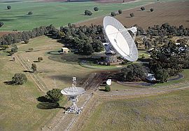
Alectown is the actual address of the Parkes Radio Telescope operated by the CSIRO, the largest radio telescope in Australia, which is used for both theoretical research and on NASA projects including the Moon landings.
Demographics
At the 2016 census, Alectown and the surrounding area had a population of 168. In the 2021 census the population had dropped to 151.
Notable residents

See also
References
- Australian Bureau of Statistics (28 June 2022). "Alectown (suburb and locality)". Australian Census 2021 QuickStats. Retrieved 28 June 2022.

- "Alectown, New South Wales". Geographical Names Register (GNR) of NSW. Geographical Names Board of New South Wales. Retrieved 1 August 2013.

- Phoenix Auctions History. "Post Office List". Phoenix Auctions. Retrieved 18 February 2021.
- "Government Gazette Notices". New South Wales Government Gazette (Sydney, NSW : 1832 - 1900). 3 December 1889. p. 8685. Retrieved 25 November 2020.
- "Government Gazette Notices". New South Wales Government Gazette (Sydney, NSW : 1832 - 1900). 24 July 1891. p. 5767. Retrieved 25 November 2020.
- "ALECTOWN POLICE STATION CLOSED". New South Wales Police Gazette and Weekly Record of Crime. 1 October 1930. p. 741. Retrieved 30 July 2024.
- "Alectown". nswgovschoolhistory.azurewebsites.net. Retrieved 30 July 2024.
- "Alectown West Station". www.nswrail.net. Retrieved 30 July 2024.
- "Satellite view - 32°56'10.0"S 148°10'21.4"E · Alectown NSW 2870, Australia". Google Maps. Retrieved 30 July 2024.
- Australian Bureau of Statistics (27 June 2017). "Alectown (State Suburb)". 2016 Census QuickStats. Retrieved 1 February 2018.

- "2021 Alectown, Census All persons QuickStats". Australian Bureau of Statistics. Retrieved 16 July 2024.
External links
| Towns in the Parkes Shire local government area | |
|---|---|
| Main Article: Local government areas of New South Wales |
This Central West geography article is a stub. You can help Misplaced Pages by expanding it. |