| Alifushi | |
|---|---|
| Inhabited island | |
 The coral sand covered streets of Alifushi The coral sand covered streets of Alifushi | |
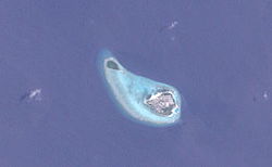
 Alifushi (right) and Eththingili Alifushi (right) and Eththingili | |
 | |
| Coordinates: 5°58′00″N 72°57′15″E / 5.96667°N 72.95417°E / 5.96667; 72.95417 | |
| Country | Maldives |
| Administrative atoll | Raa Atoll |
| Distance to Malé | 207.43 km (128.89 mi) |
| Area | |
| • Total | 0.31 km (0.12 sq mi) |
| Dimensions | |
| • Length | 0.950 km (0.590 mi) |
| • Width | 0.750 km (0.466 mi) |
| Population | |
| • Total | 2,700 |
| • Density | 8,700/km (23,000/sq mi) |
| Time zone | UTC+05:00 (MST) |
Alifushi (Dhivehi: އަލިފުށި) is one of the inhabited islands of Raa Atoll in the Maldives.
History
Powell Islands
Alifushi and Etthingili were named as the Powell Islands by Captain Robert Moresby after Lieutenant F.F. Powell, who assisted during the difficult survey of the Atolls of the Maldives in 1834–36. Later promoted to captain, Powell went on to survey the northwest coast of Ceylon.
...and the ink of the Maldive charts had scarcely dried, when the labours of those employed were demanded of the Indian Government by Her Majesty’s authorities at Ceylon, to undertake trigonometrical surveys of that Island, and the dangerous and shallow gulfs on either side of the neck of sand connecting it with India. They were the present Captains F. F. Powell, and Richard Ethersey, in the Schooner 'Royal Tiger' and 'Shannon,' assisted by Lieut. (now Commander) Felix Jones, and the late Lieut. Wilmot Christopher, who fell in action before Mooltan. The first of these officers had charge of one of the tenders under Lieut. Powell, and the latter another under Lieut. Ethersey. The maps of the Pamban Pass and the Straits of Manaar were by the hand of Lieut. Felix Jones, who was the draftsman also on this survey: they speak for themselves.
— from Richard F. Burton's First Footsteps in East Africa.
Geography
Alifushi and Etthingili (Powell Islands in the Admiralty Chart) stand on a detached reef of their own with very deep waters (no sounding), between this isolated reef shelf and the northern end of the main Northern Maalhosmadulhu Atoll.
Alifushi is 207.43 km (129 mi; 112 nmi) north of the country's capital, Malé.
Demography
| Year | Pop. | ±% |
|---|---|---|
| 2006 | 1,974 | — |
| 2014 | 1,578 | −20.1% |
| 2006-2014: Census populations Source: | ||
Economy
This island is renowned for its carpenters and boat builders.
References
- "Table PP5: Resident Population by sex, nationality and locality (administrative islands), 2014" (PDF). Population and Households Census 2014. National Bureau of Statistics. p. 34. Retrieved 11 August 2018.
- Burton, Richard (1894). First Footsteps in East Africa. Vol. I. London: Tylston and Edwards. Preface: XX. OCLC 4872739.
- "Coordinate Distance Calculator". Boulter.com. Retrieved 11 August 2018.
- "Table 3.3: Total Maldivian Population by Islands" (PDF). National Bureau of Statistics. Retrieved 11 August 2018.
| Island-level constituencies of the Maldives | ||
|---|---|---|
| Haa Alif | ||
| Haa Dhaalu | ||
| Shaviyani | ||
| Noonu | ||
| Raa | ||
| Baa | ||
| Lhaviyani | ||
| Kaafu | ||
| Alif Alif | ||
| Alif Dhaalu | ||
| Vaavu | ||
| Meemu | ||
| Faafu | ||
| Dhaalu | ||
| Kolhumadulu (Thaa) | ||
| Laamu | ||
| Gaafu Alif | ||
| Gaafu Dhaalu | ||
| Gnaviyani | ||
| The capitals of each atoll are in underline. This list excludes first-level administrative divisions, Malé and Addu cities. | ||
This Maldives location article is a stub. You can help Misplaced Pages by expanding it. |