Commune in Moselle, Grand Est, France Commune in Grand Est, France
| Amnéville | |
|---|---|
| Commune | |
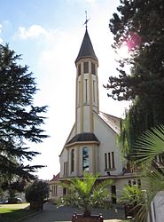
 The church in Amnéville The church in Amnéville | |
 Coat of arms Coat of arms | |
| Location of Amnéville | |
  | |
| Coordinates: 49°15′41″N 6°08′33″E / 49.2614°N 6.1425°E / 49.2614; 6.1425 | |
| Country | France |
| Region | Grand Est |
| Department | Moselle |
| Arrondissement | Metz |
| Canton | Rombas |
| Intercommunality | Pays Orne-Moselle |
| Government | |
| • Mayor (2020–2026) | Éric Munier |
| Area | 10.46 km (4.04 sq mi) |
| Population | 10,828 |
| • Density | 1,000/km (2,700/sq mi) |
| Time zone | UTC+01:00 (CET) |
| • Summer (DST) | UTC+02:00 (CEST) |
| INSEE/Postal code | 57019 /57360 |
| Elevation | 157–366 m (515–1,201 ft) (avg. 130 m or 430 ft) |
| French Land Register data, which excludes lakes, ponds, glaciers > 1 km (0.386 sq mi or 247 acres) and river estuaries. | |
Amnéville (French pronunciation: [amnevil]; German: Amenweiler, 1940–45: Stahlheim) is a commune in the Moselle department in Grand Est in northeastern France. The town is an important tourist and thermal spa centre in France.
Geography
Amnéville is located in the Moselle valley, between Metz and Thionville.
Population
|
| |||||||||||||||||||||||||||||||||||||||||||||||||||||||||||||||
| ||||||||||||||||||||||||||||||||||||||||||||||||||||||||||||||||
| Source: EHESS and INSEE (1968–2017) | ||||||||||||||||||||||||||||||||||||||||||||||||||||||||||||||||
History
A Celtic presence on the municipal territory of Amnéville has been attested since the 6th century BC. Excavations have demonstrated the existence of a village and a necropolis.
Amnéville was part of the Duchy of Bar until 1480, then of the Duchy of Lorraine.
During the first German annexation, in 1894, the municipality of Amnéville was created by splitting the municipality of Gandrange. The Rombas factory was created at this time. The new municipality was named Stahlheim, literally "City of Steel". Stahlheim-Amnéville, will later be renamed Amnéville-Stahlheim. It became French again in 1919. In 1974, it absorbed the former commune Malancourt-la-Montagne.
Sights
- Traces of Roman road
- Remains of a Roman bridge
- 14th-century castle and church
- Zoo d'Amnéville
Other sights include the casino that hosted a stage of the 2010/2011 World Poker Tour season and an indoor ski slope. Amnéville also has a tourist and thermal center.
Personalities
Sport
See also
References
- "Répertoire national des élus: les maires" (in French). data.gouv.fr, Plateforme ouverte des données publiques françaises. 13 September 2022.
- "Populations légales 2021" (in French). The National Institute of Statistics and Economic Studies. 28 December 2023.
- Des villages de Cassini aux communes d'aujourd'hui: Commune data sheet Amnéville, EHESS (in French).
- Population en historique depuis 1968, INSEE
- Modifications aux circonscriptions administratives territoriales (fusion de communes), Journal officiel de la République française n° 0167, 20 July 1973, pp. 7891-7892.
- www.poker.fr, December 18, 2009 Archived December 21, 2009, at the Wayback Machine
External links
This Arrondissement of Metz geographical article is a stub. You can help Misplaced Pages by expanding it. |