| Amudarya district Әмиўдәрья районы, Ámiwdárya rayonı (Karakalpak) | |
|---|---|
| District | |
| Amudarya district | |
 | |
| Country | |
| Autonomous Republic | Karakalpakstan |
| Capital | Mangit |
| Area | |
| • Total | 1,020 km (390 sq mi) |
| Population | |
| • Total | 204,700 |
| • Density | 200/km (520/sq mi) |
| Time zone | UTC+5 (UZT) |
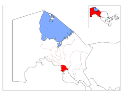
The Amudarya district (Karakalpak: Әмиўдәрья районы, Ámiwdárya rayonı) is a district of Karakalpakstan in Uzbekistan. The capital lies at Mangit. Its area is 1,020 km (390 sq mi), and it had 204,700 inhabitants in 2022.
There are one city Mangit, four towns Jumurtov, Kipshak, Kilishbay and Xitay and 16 village councils Nazarxan, Orta-qala, Kipshak, Quyuq-kopir, Xitay, Aq altin, Shaykul, Kilishbay, Kanli, Amir Temur, Durman, Bobur nomli, Buzyop, Tolqin, Tashyop and Xolimbeg.
Notable people
The following people were born in the city.
- Islombek Pirmanov (born 1995), boxer.
References
- ^ "Classification system of territorial units of the Republic of Uzbekistan" (in Uzbek and Russian). The State Committee of the Republic of Uzbekistan on statistics. July 2020.
- "Qoraqalpog'iston Respublikasining ma'muriy-hududiy bo'linishi" [Administrative-territorial division of the Republic of Karakalpakstan] (PDF) (in Uzbek). Karakalpakstan Republic department of statistics.
- "Hududlar bo'yicha shahar va qishloq aholisi soni" [Urban and rural population by district] (PDF) (in Uzbek). Karakalpakstan Republic department of statistics.
This Uzbekistan location article is a stub. You can help Misplaced Pages by expanding it. |
| Karakalpakstan | ||
|---|---|---|
| Capital: Nukus | ||
| Districts |  | |
| Cities | ||
| Towns | ||
39°13′30″N 64°41′02″E / 39.225°N 64.684°E / 39.225; 64.684
Categories: