| Anadyrsky Liman Анадырский Лиман | |
|---|---|
| Estuary | |
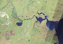
 The lower Anadyr showing the Anadyrskiy Liman, the sand bar, and tributaries. The Gulf of Anadyr is partially shown to the right The lower Anadyr showing the Anadyrskiy Liman, the sand bar, and tributaries. The Gulf of Anadyr is partially shown to the right | |
 | |
| Coordinates: 64°29′51″N 178°23′29″E / 64.49750°N 178.39139°E / 64.49750; 178.39139 | |
| Country | Russian Federation |
| Federal subject | Far Eastern Federal District |
| Federal subject | Chukotka Autonomous Okrug |
Anadyrskiy Liman (Russian: Анадырский Лиман) or Anadyr Estuary is an estuary on the Gulf of Anadyr in Chukotka Autonomous Okrug, Siberia, Russian Federation.
Geography
It is called a liman because it is separated from the Gulf of Anadyr by the Russkaya Koshka spit in the north and another spit (Geka Point) in the south. The channel into the Gulf of Anadyr through the bar is in the east. The Anadyr Lowlands are located to the west.
Anadyrskiy Liman is divided into three parts. The outer bay receives the Tretya River (its mouth is the notch on the south shore). The southern part of the outer bay is shallow. The inner bay is called Onemen Bay and receives the Velikaya through a narrow bay on the southwest. They are separated by a promontory, with the town of Anadyr at its tip. North of the promontory is a series of lakes which form the mouth of the Kanchalan River. The Anadyr River enters the inner bay from the west. The lake south of the Anadyr in this image is Lake Krasnoye.
References
- Google Earth
- DMA 96621 "Anadyrskiy Liman and Zaliv 1" United States Defence Mapping Agency, now under National Geospatial-Intelligence Agency (NGIA)
- United States Hydrographic Office (1909). Asiatic pilot, Volume 1. Issues 122-126; Issue 162 of H.O. pub. Gov. Printing Off., Washington. pp 50-51.
External links
- "Anadyrskiy Liman" Geonames
This Chukotka Autonomous Okrug location article is a stub. You can help Misplaced Pages by expanding it. |