| Ankogel | |
|---|---|
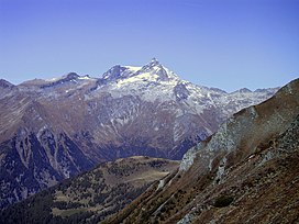
 The Ankogel (centre) The Ankogel (centre) | |
| Highest point | |
| Elevation | 3,252 m (10,669 ft) |
| Prominence | 576 m (1,890 ft) |
| Listing | Alpine mountains above 3000 m |
| Coordinates | 47°03′00″N 13°15′00″E / 47.05000°N 13.25000°E / 47.05000; 13.25000 |
| Geography | |
 | |
| Location | Carinthia / Salzburg, Austria |
| Parent range | High Tauern |
| Climbing | |
| First ascent | c. 1742 |
The Ankogel (3,252 m) is a mountain in the Ankogel Group in the eastern High Tauern range in Austria. It is the second highest mountain in the group, the Hochalmspitze being higher at 3,360 m.
A cable car from Mallnitz goes up to 2,631 m on the mountain, making Ankogel one of the most accessible alpine peaks.
References
- "Ankogel - Peakvisor". peakvisor.com. Retrieved 25 May 2020.
- Braham, Trevor (2013). When the Alps Cast Their Spell: Mountaineers of the Alpine Golden Age. Neil Wilson Publishing. ISBN 9781906476342.
- "Österreichische Karte 1:50.000 (ÖK 50)". austrianmap.at. Retrieved 5 January 2015.
This Austrian location article is a stub. You can help Misplaced Pages by expanding it. |