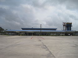
| Antonio Roldán Betancur Airport Aeropuerto Antonio Roldán Betancur | |||||||||||
|---|---|---|---|---|---|---|---|---|---|---|---|
 | |||||||||||
| Summary | |||||||||||
| Airport type | Public | ||||||||||
| Operator | Grupo Aeroportuario del Sureste | ||||||||||
| Serves | Apartadó, Colombia | ||||||||||
| Elevation AMSL | 52 ft / 16 m | ||||||||||
| Coordinates | 7°48′45″N 76°43′00″W / 7.81250°N 76.71667°W / 7.81250; -76.71667 | ||||||||||
| Map | |||||||||||
  | |||||||||||
| Runways | |||||||||||
| |||||||||||
| Statistics (2023) | |||||||||||
| |||||||||||
| Source: Grupo Aeroportuario del Sureste | |||||||||||
Antonio Roldán Betancur Airport (IATA: APO, ICAO: SKLC) is an airport serving Apartadó, a town in the Antioquia Department of Colombia. The airport is in the countryside 12 kilometres (7.5 mi) southwest of Apartadó. It is named after Antonio Roldán Betancur, who was governor of Antioquia from 1988 until his assassination in 1989.
The Los Cedros VOR-DME (Ident: LCE) is located on the field.
In 2016, the airport handled 210,550 passengers, and 201,330 in 2017.
Airlines and destinations
| Airlines | Destinations |
|---|---|
| Clic | Medellín–Olaya Herrera |
| SATENA | Bogotá, Medellín–Olaya Herrera |
See also
References
- "Passnenger Traffic" (PDF) (in Spanish). Grupo Aeroportuario del Sureste. January 2024. Retrieved January 12, 2024.
- Los Cedros VOR
External links
- OurAirports - Antonio Roldán Betancourt
- SkyVector - Antonio Roldán Betancourt
- FallingRain - Antonio Roldán Betancourt Airport
- Accident history for APO at Aviation Safety Network
- Current weather for SKLC at NOAA/NWS
| Airports in Colombia | |
|---|---|
| Major international | |
| Minor international | |
| Domestic |
|
| Unscheduled | |
| Statistics | |
This article about an airport in Colombia is a stub. You can help Misplaced Pages by expanding it. |