| Araçuaí | |
|---|---|
 Monument at the city entrance Monument at the city entrance | |
 Flag Flag Seal Seal | |
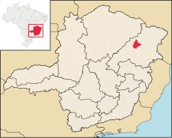
 Location in the state of Minas Gerais Location in the state of Minas Gerais | |
 | |
| Coordinates: 16°51′00″S 42°04′12″W / 16.85000°S 42.07000°W / -16.85000; -42.07000 | |
| Country | Brazil |
| State | Minas Gerais |
| Mesoregion | Jequitinhonha |
| Microregion | Araçuaí |
| Incorporated (municipality) | 21 September 1871 |
| Government | |
| • Mayor | Tadeu Barbosa de Oliveira |
| Area | |
| • Total | 2,236.279 km (863.432 sq mi) |
| Population | |
| • Total | 36,712 |
| • Density | 16/km (43/sq mi) |
| Demonym | araçuaiense |
| Time zone | UTC−3 (BRT) |
| CEP postal code | 39600-000 |
| Area code | 33 |
| Website | aracuai.mg.gov.br |
Araçuaí (Portuguese pronunciation: [aɾɐswa'i]) is a Brazilian municipality located in the northeast of the state of Minas Gerais in the Jequitinhonha River valley. The Araçuaí River, a tributary of the Jequitinhonha, flows through it. Its population as of 2020 was estimated to be 36,712 people living in a total area of 2,235 km. The city belongs to the mesoregion of Jequitinhonha and the microregion of Araçuaí. The city is the seat of the Roman Catholic Diocese of Araçuaí. The elevation of the municipal seat is 307 meters. It became a municipality in 1870.
Between the municipalities of Araçuaí and Itinga is located the largest lithium mine in Brazil, explored and extracted by Sigma Lithium Resources.
Etymology
The origin of the name "Araçuaí" has two versions: according to Auguste de Saint-Hilaire, the name was given by the paulistas to the river because they had found a large quantity of gold in it. They exclaimed: "ouro só ali" ("only gold there"), and from this phrase Araçuaí was created. According to philologist Eduardo de Almeida Navarro, Araçuaí comes from the Tupi language, through the composition of the words araso'iá (araçoia) and 'y (river), therefore meaning "river of the araçoias".
Until 1857, the place was called Calhau, due to the large quantity of pebbles (calhais) in the region.
History
Before the arrival of the Europeans, the current municipality of Araçuaí was inhabited by the Tocoió and Botocudo indigenous.
The priest Carlos Pereira de Moura had founded the Aldeia do Pontal, currently Itira. The village was located next to the confluence of two large rivers: the Jequitinhonha and the Araçuaí. The village had a set of qualities to evolve into a city, such as easy access to canoes, used at the time for navigating rivers, but the priest was excessively demanding and authoritarian, prohibiting alcoholic beverages and prostitutes there. So, the prostitutes emigrated up the Araçuaí River, and the canoeists changed ports, attracted by them.
The prostitutes were sheltered by Luciana Teixeira, owner of the Fazenda da Boa Vista da Barra do Calhau, on her lands on the right bank of the Calhau and Araçuaí streams. This became the landing point for the canoes that went up the Jequitinhonha. Luciana started a village on her land in 1817.
Over time, the place gained importance. It was established under the name Vila de Arassuahy on July 1, 1871, and on September 21 of the same year it was elevated to the category of city, with the name Araçuaí.
Until 1911, the city was the capital of the entire northeast of Minas Gerais. In 1882, the Bahia and Minas Railway was built, connecting the Bahian city of Caravelas to Araçuaí, but it was deactivated and closed in 1966.
Today, Araçuaí is considered one of the commercial and educational centers of the Jequitinhonha valley.
Geography
According to the regional division in force since 2017, established by the IBGE, the municipality belongs to the Intermediate Geographic Region of Teófilo Otoni and Immediate Geographic Region of Araçuaí. Until then, with the divisions into microregions and mesoregions in force, it was part of the microregion of Araçuaí, which in turn was included in the mesoregion of Jequitinhonha.
Climate
The maximum temperature of 44.8 °C (112.6 °F) recorded on November 19, 2023, in Araçuaí, is considered the highest ever maximum temperature recorded in Brazil.
| Climate data for Araçuaí (1991–2020) | |||||||||||||
|---|---|---|---|---|---|---|---|---|---|---|---|---|---|
| Month | Jan | Feb | Mar | Apr | May | Jun | Jul | Aug | Sep | Oct | Nov | Dec | Year |
| Mean daily maximum °C (°F) | 33.7 (92.7) |
34.7 (94.5) |
33.7 (92.7) |
32.6 (90.7) |
30.9 (87.6) |
29.8 (85.6) |
29.6 (85.3) |
31.0 (87.8) |
32.8 (91.0) |
34.0 (93.2) |
32.3 (90.1) |
32.8 (91.0) |
32.3 (90.1) |
| Daily mean °C (°F) | 26.7 (80.1) |
27.2 (81.0) |
26.7 (80.1) |
25.7 (78.3) |
23.8 (74.8) |
22.5 (72.5) |
22.2 (72.0) |
23.5 (74.3) |
25.5 (77.9) |
26.9 (80.4) |
26.1 (79.0) |
26.2 (79.2) |
25.3 (77.5) |
| Mean daily minimum °C (°F) | 21.6 (70.9) |
21.8 (71.2) |
21.7 (71.1) |
20.7 (69.3) |
18.4 (65.1) |
16.7 (62.1) |
16.2 (61.2) |
17.1 (62.8) |
19.7 (67.5) |
21.6 (70.9) |
21.6 (70.9) |
21.5 (70.7) |
19.9 (67.8) |
| Average precipitation mm (inches) | 109.7 (4.32) |
79.3 (3.12) |
95.8 (3.77) |
27.9 (1.10) |
16.8 (0.66) |
3.5 (0.14) |
4.0 (0.16) |
4.7 (0.19) |
11.3 (0.44) |
51.8 (2.04) |
149.3 (5.88) |
153.1 (6.03) |
707.2 (27.84) |
| Average precipitation days (≥ 1.0 mm) | 8 | 6 | 8 | 4 | 2 | 1 | 1 | 1 | 1 | 4 | 10 | 11 | 57 |
| Average relative humidity (%) | 66.0 | 62.2 | 65.4 | 64.7 | 63.8 | 62.2 | 58.9 | 53.8 | 51.2 | 53.3 | 65.2 | 69.4 | 61.3 |
| Source: Instituto Nacional de Meteorologia | |||||||||||||
Economy
The city's GDP is around R$520 million reais, with 50.3% of the added value coming from services, followed by public administration (33.6%), industry (11%) and agriculture (5.1%). With this structure, the GDP per capita of Araçuaí is R$ 14.2 thousand, a value lower than the state average (R$ 40.1 thousand) and the region of Teófilo Otoni (R$ 14.9 thousand), but higher than the average of the municipalities in the region of Araçuaí (R$ 11.4 thousand).
Culture
In the city, the Araçuaí Museum was created to house the collection of objects and documents that record the religiosity, customs and activities that make up the history of Araçuaí and the region. The museum was created by the artist Lira Marques and Frei Chico, a Dutch Franciscan friar who worked as a researcher of Brazilian popular culture and religiosity. Every year, in September, the city holds the Micareta de Araçuaí, an off-season carnival that attracts many people from the region.
See also
References
- "IBGE - Cidades e Estados" [IBGE - Cities and States] (in Portuguese). Brazilian Institute of Geography and Statistics (IBGE). 2017. Retrieved 2019-07-11.
- IBGE 2020
- "IBGE - Brasil em Síntese". Brazilian Institute of Geography and Statistics (IBGE). Retrieved 2019-11-13.
- "Lítio pode impulsionar o desenvolvimento do Vale do Jequitinhonha - Assembleia Legislativa de Minas Gerais". Portal da Assembleia Legislativa de Minas Gerais (in Brazilian Portuguese). Retrieved 2024-08-16.
- "A corrida pela riqueza do lítio na pequena Araçuaí - revista piauí". revista piauí - _pra quem tem um clique a mais. 2024-07-19. Retrieved 2024-08-16.
- "Sigma Lithium Resources". Sigma Lithium (in Brazilian Portuguese). Retrieved 2024-08-16.
- Navarro, Eduardo de Almeida (2013). Dicionário de tupi antigo: a língua indígena clássica do Brasil (1.ª ed.). São Paulo: Global. ISBN 9788526019331.
- "Portal IFNMG - Historia da cidade de Araçuai". www.ifnmg.edu.br. Retrieved 2024-08-16.
- ^ "História - Prefeitura de Araçuaí". www.aracuai.mg.gov.br. Retrieved 2024-08-16.
- Instituto Brasileiro de Geografia e Estatística (IBGE) (2017). "Base de dados por municípios das Regiões Geográficas Imediatas e Intermediárias do Brasil". Retrieved 30 October 2017.
- Instituto Brasileiro de Geografia e Estatística (IBGE) (2016). "Divisão Territorial Brasileira 2016". Retrieved 30 October 2017.
- "83442: Aracuai (Brazil)". ogimet.com. OGIMET. 19 November 2023. Retrieved 21 November 2023.
- "Temperatura Máxima Mensal e Anual (°C)". Normais Climatológicas do Brasil 1991-2020 (in Portuguese). Instituto Nacional de Meteorologia. Archived from the original on 24 March 2022. Retrieved 20 April 2024.
- "Temperatura Média Compensada Mensal e Anual (°C)". Normais Climatológicas do Brasil 1991-2020 (in Portuguese). Instituto Nacional de Meteorologia. Archived from the original on 24 March 2022. Retrieved 20 April 2024.
- "Temperatura Mínima Mensal e Anual (°C)". Normais Climatológicas do Brasil 1991-2020 (in Portuguese). Instituto Nacional de Meteorologia. Archived from the original on 24 March 2022. Retrieved 20 April 2024.
- "Precipitação Acumulada Mensal e Anual (mm)". Normais Climatológicas do Brasil 1991-2020 (in Portuguese). Instituto Nacional de Meteorologia. Archived from the original on 24 March 2022. Retrieved 20 April 2024.
- "Número de dias no mês ou no ano com precipitação maior ou igual a (1 mm) (dias)". Normais Climatológicas do Brasil 1991-2020 (in Portuguese). Instituto Nacional de Meteorologia. Archived from the original on 24 March 2022. Retrieved 20 April 2024.
- "Umidade Relativa do Ar Compensada Mensal e Anual (%)". Normais Climatológicas do Brasil 1991-2020 (in Portuguese). Instituto Nacional de Meteorologia. Archived from the original on 24 March 2022. Retrieved 20 April 2024.
- "Insolação Total (horas)". Normais Climatológicas do Brasil 1991-2020 (in Portuguese). Instituto Nacional de Meteorologia. Archived from the original on 24 March 2022. Retrieved 20 April 2024.
- ^ "Economia de Araçuaí - MG". Caravela (in Portuguese). Retrieved 2024-08-16.
- ^ Gerais, Portal Minas. "Turismo em Minas Gerais | Museu de Araçuaí". Portal Minas Gerais (in Brazilian Portuguese). Retrieved 2024-08-16.
- "Prefeitura de Araçuai anuncia realização da Micareta, com Wesley Safadão entre as atrações". Gazeta de Araçuaí (in Brazilian Portuguese). 2023-06-26. Retrieved 2024-08-16.
