Suburb of Palmerston, the Northern Territory, Australia
| Archer Palmerston, Northern Territory | |||||||||||||||
|---|---|---|---|---|---|---|---|---|---|---|---|---|---|---|---|
 Archer in the southwestern part of the City of Palmerston Archer in the southwestern part of the City of Palmerston | |||||||||||||||
 | |||||||||||||||
| Coordinates | 12°30′44″S 130°58′16″E / 12.512105°S 130.971015°E / -12.512105; 130.971015 | ||||||||||||||
| Population | 0 (2016 census) | ||||||||||||||
| Established | 1970s | ||||||||||||||
| Postcode(s) | 0830 | ||||||||||||||
| Location |
| ||||||||||||||
| LGA(s) | City of Palmerston | ||||||||||||||
| Territory electorate(s) | Blain | ||||||||||||||
| Federal division(s) | Solomon | ||||||||||||||
| |||||||||||||||
| Footnotes | Adjoining suburbs | ||||||||||||||
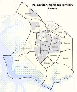
Archer is a relatively new and still sparsely populated suburb in the southwestern part of Palmerston. It is 25 km SE of the Darwin CBD and 5.4 km from Palmerston City. It is on the traditional Country and waterways of the Larrakia people. Its local government area is the City of Palmerston. Archer is the largest suburb of Palmerston by area.
The suburb was named after James C. Archer, former Administrator of the Northern Territory.
References
- Australian Bureau of Statistics (27 June 2017). "Archer (State Suburb)". 2016 Census QuickStats. Retrieved 28 June 2017.

- "Search result for 'Archer'". NT Atlas and Spatial Data Directory. Northern Territory Government. Retrieved 10 June 2019.
- "Palmerston City Council Suburbs" (PDF). Place Names Committee. Northern Territory Government. Archived from the original (PDF) on 18 March 2019. Retrieved 10 June 2019.
- "The Larrakia People". Larrakia Nation. 31 March 2023. Retrieved 24 February 2024.
- "Biography: Previous Incumbents – James Clarence Archer" (PDF). Government House NT. Northern Territory Government. Archived from the original (PDF) on 2 April 2011. Retrieved 2 April 2012.
External links
| Suburbs of the City of Palmerston, Darwin, Northern Territory | |
|---|---|
| Inner City | |
| Outskirts | |