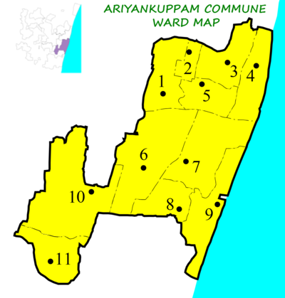
Ariyankuppam is one of 5 Communes in Pondicherry district in the Indian territory of Puducherry. It is the only commune under Puducherry Taluk. Other communes are under Villianur and Bahour Taluk. Ariyankuppam Commune consists of 2 Census Town and 9 Panchayat Villages.
Ariyankuppam holds two vital tourist spots of Puducherry namely:
- Aricamedu, An Archaeological Site
- Chunnambar Boat House
Commune wards

| Ward Number | Ward Name | Town/Village | Area (km) | Population (2011 Census) | Jurisdiction | Ward Map |
|---|---|---|---|---|---|---|
| 1 | Ariyankuppam (West) | Village |
|
 | ||
| 2 | Ariyankuppam | Town |
|
|||
| 3 | Kakkayanthope | Village |
|
 | ||
| 4 | Veerampattinam | Village |
|
 | ||
| 5 | Manavely | Town |
|
 | ||
| 6 | Thavalakuppam | Village |
|
 | ||
| 7 | Pooranankuppam | Village |
|
 | ||
| 8 | Nallavadu | Village |
|
 | ||
| 9 | Andiyarpalayam | Village |
|
 | ||
| 10 | Abishegapakkam | Village |
|
 | ||
| 11 | Thimma Nayakan Palayam | Village |
|
 |
References
- 2011 Census data Chapter 4 censusindia.gov.in
- "List of village panchayats in Puducherry district" (PDF). District Rural Development Agency, Department of Rural Development, Government of Puducherry. Archived from the original (PDF) on 27 September 2013. Retrieved 2 February 2013.
- Ariyankuppam and Manavely are noted as census towns in census 2011.
- "List of Ancient Monuments and Archaeological Sites and Remains of Pondicherry - Archaeological Survey of India". Archived from the original on 19 November 2016. Retrieved 25 February 2013.
External links
| Puducherry district | |
|---|---|
| Taluks | |
| Administrative blocks | |
| Communes | |
| Municipalities | |
| Census towns | |
| Gram panchayats | |
| Wards | |
11°53′49.16″N 79°48′18.56″E / 11.8969889°N 79.8051556°E / 11.8969889; 79.8051556
This article related to a location in the Indian union territory of Puducherry is a stub. You can help Misplaced Pages by expanding it. |