| Ascrea | |
|---|---|
| Comune | |
| Comune di Ascrea | |
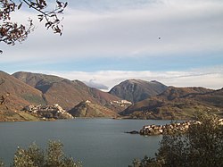
 Turano Lake with Ascrea in background Turano Lake with Ascrea in background | |
 Coat of arms Coat of arms | |
 Ascrea within the Province of Rieti Ascrea within the Province of Rieti | |
| Location of Ascrea | |
  | |
| Coordinates: 42°11′49″N 12°59′51″E / 42.19694°N 12.99750°E / 42.19694; 12.99750 | |
| Country | Italy |
| Region | Lazio |
| Province | Rieti (RI) |
| Frazioni | Stipes, Valleverde Stipes |
| Government | |
| • Mayor | Dante D'Angeli |
| Area | |
| • Total | 14.4 km (5.6 sq mi) |
| Elevation | 318 m (1,043 ft) |
| Population | |
| • Total | 250 |
| • Density | 17/km (45/sq mi) |
| Demonym | Ascreani |
| Time zone | UTC+1 (CET) |
| • Summer (DST) | UTC+2 (CEST) |
| Postal code | 02020 |
| Dialing code | 0765 |
| Website | Official website |
Ascrea is a comune (municipality) in the Province of Rieti in the Italian region of Latium, located about 50 kilometres (31 mi) northeast of Rome and about 25 kilometres (16 mi) southeast of Rieti.
Geography
It is an agricultural centre in the middle valley of the river Turano [it]}. The municipality borders with Castel di Tora, Collegiove, Longone Sabino, Marcetelli, Paganico Sabino, Pozzaglia Sabina, Rocca Sinibalda and Varco Sabino.
The municipal territory includes a northern exclave in which are located its hamlets (frazioni): Stipes and Valleverde Stipes. A southeastern exclave is located few kilometers from the town.
References
- "Superficie di Comuni Province e Regioni italiane al 9 ottobre 2011". Italian National Institute of Statistics. Retrieved 16 March 2019.
- All demographics and other statistics: Italian statistical institute Istat.
- 41840 (x j a h) Ascrea on OpenStreetMap
External links
![]() Media related to Ascrea at Wikimedia Commons
Media related to Ascrea at Wikimedia Commons
This Lazio location article is a stub. You can help Misplaced Pages by expanding it. |