| Ashton | |
|---|---|
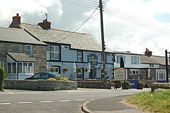
 The Lion and Lamb public house The Lion and Lamb public house | |
 | |
| Civil parish | |
| Unitary authority | |
| Ceremonial county | |
| Region | |
| Country | England |
| Sovereign state | United Kingdom |
| Police | Devon and Cornwall |
| Fire | Cornwall |
| Ambulance | South Western |
| 50°06′32″N 5°21′14″W / 50.109°N 5.354°W / 50.109; -5.354 | |
Ashton (Cornish: Trevonnen) is a village in the civil parish of Breage, west Cornwall, England, UK at OS grid ref SW604286. It is on the A394 Penzance – Helston road one mile north-east of Praa Sands.
A Mission Church designed by James Piers St Aubyn was dedicated by George Wilkinson (Bishop of Truro) on 11 March 1884. Costing between £600 and £700, it is built in the Gothic early-English style on a site donated by the Duke of Leeds. Ashton has a pub called the Lion and Lamb and in the past had a football team.
Ashton is also the name of places in the parishes of Poundstock, St Dominick and St Winnow. The meaning of Ashton is "ash-tree farm".
References
- OS Explorer. Land's End (Map). Southampton: Ordnance Survey. 2015. ISBN 9 780319 243046.
- "Opening Of A Mission-Church At Ashton, Breage". The Cornishman. No. 296. 13 March 1884. p. 8.
- Weatherhill, Craig (2009). A Concise Dictionary of Cornish Place-Names. Westport, County Mayo: Evertype. p. 19. ISBN 9781904808220.
| Cornwall Portal | |
| Unitary authorities | |
| Major settlements (cities in italics) |
|
| Rivers | |
| Topics | |
This article about a location in the former district of Kerrier, Cornwall is a stub. You can help Misplaced Pages by expanding it. |