| Site of Special Scientific Interest | |
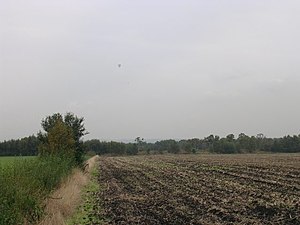
 Looking west across fields on Astley Moss Looking west across fields on Astley Moss | |
 | |
| Location | Greater Manchester |
|---|---|
| Grid reference | SJ 691 975 |
| Coordinates | 53°28′22″N 2°27′02″W / 53.4729°N 2.4506°W / 53.4729; -2.4506 |
| Interest | Biological |
| Area | 228 acres (92 ha; 0.36 sq mi) |
| Notification | 1989 |
Astley and Bedford Mosses are areas of peat bog south of the Bridgewater Canal and north of the Liverpool and Manchester Railway. They are situated about 2+1⁄2 miles (4 km) south-east of Leigh, in Astley and Bedford, Greater Manchester, England. They are among the last remaining fragments of Chat Moss, the raised bog that once covered a large area, of around 10+2⁄3 square miles (28 km), south Lancashire north of the River Mersey. Astley Moss was designated a Site of Special Scientific Interest in 1989. Astley and Bedford Mosses, along with Risley Moss and Holcroft Moss, are part of Manchester Mosses, a European Union designated Special Area of Conservation.
Ecology
Chat Moss, a lowland raised bog, formed after the last ice age about 10,000 years ago on the site of a shallow glacial lake to the north of the River Mersey. Fen peat formed in an area colonised by reeds and rushes. Sphagnum mosses then colonised the area causing a change from fen to bog peat which became elevated forming a dome, the raised bog. Sphagnum mosses increase the acidity of the water resulting in highly specialised plant species, many of them found nowhere else. The site is also important for bird species such as the merlin, hen harrier and short-eared owl.
References
- "Astley & Bedford Mosses" (PDF). Natural England.
- Astley Moss, lancswt.org.uk, archived from the original on 20 July 2011, retrieved 20 January 2011
- Manchester Mosses, Joint Nature Conservation Committee, retrieved 20 January 2011
- Lowland Mosslands (pdf), Greater Manchester Biodiversity Project, p. 1, retrieved 21 January 2011
- "Astley Moss SSSI". Wigan Council. Retrieved 5 July 2018.