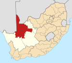
Place in Northern Cape, South Africa
| Augrabies | |
|---|---|
  | |
| Coordinates: 28°39′36″S 20°25′50″E / 28.66000°S 20.43056°E / -28.66000; 20.43056 | |
| Country | South Africa |
| Province | Northern Cape |
| District | ZF Mgcawu |
| Municipality | Kai !Garib |
| Area | |
| • Total | 3.82 km (1.47 sq mi) |
| Population | |
| • Total | 3,627 |
| • Density | 950/km (2,500/sq mi) |
| Racial makeup (2011) | |
| • Black African | 36.8% |
| • Coloured | 47.1% |
| • Indian/Asian | 2.8% |
| • White | 9.4% |
| • Other | 3.9% |
| First languages (2011) | |
| • Afrikaans | 66.7% |
| • Tswana | 28.8% |
| • English | 1.6% |
| • Other | 2.8% |
| Time zone | UTC+2 (SAST) |
| PO box | 8874 |
| Area code | 054 |
Augrabies /ɔːˈxrɑːbiːz/ is a small town in the Northern Cape province of South Africa, situated on the south bank of the Orange River about 100 kilometres (60 mi) downstream from Upington. It is located on the R359 road just outside the Augrabies Falls National Park, which contains the Augrabies Falls for which the town is named.
References
- ^ "Main Place Augrabies". Census 2011.
- "Augrabies". Northern Cape Tourism Authority. Archived from the original on 22 February 2010. Retrieved 11 March 2010.
- "Augrabies Attractions". SA-Venues.com. Retrieved 11 March 2010.
| Municipalities and communities of ZF Mgcawu District Municipality, Northern Cape | ||
|---|---|---|
| District seat: Upington | ||
| Dawid Kruiper |  | |
| Kai !Garib | ||
| Kgatelopele | ||
| !Kheis | ||
| Tsantsabane | ||
This Northern Cape location article is a stub. You can help Misplaced Pages by expanding it. |