| Azuga | |
|---|---|
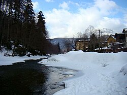
 The Azuga upstream of the town of Azuga The Azuga upstream of the town of Azuga | |
 | |
| Location | |
| Country | Romania |
| Counties | Brașov, Prahova |
| Physical characteristics | |
| Source | Baiu Mountains |
| • coordinates | 45°29′49″N 25°41′32″E / 45.49694°N 25.69222°E / 45.49694; 25.69222 |
| Mouth | Prahova |
| • location | Azuga |
| • coordinates | 45°26′30″N 25°33′03″E / 45.44167°N 25.55083°E / 45.44167; 25.55083 |
| • elevation | 926 m (3,038 ft) |
| Length | 23 km (14 mi) |
| Basin size | 88 km (34 sq mi) |
| Basin features | |
| Progression | Prahova→ Ialomița→ Danube→ Black Sea |
The Azuga is a left tributary of the river Prahova in Romania. It discharges into the Prahova in the town Azuga. Its length is 23 km (14 mi) and its basin size is 88 km (34 sq mi).
Tributaries
The following rivers are tributaries to the river Azuga (from source to mouth):
- Left: Pârâul Roșu, Retevoi, Valea Lacului Roșu, Valea Turcului, Ștevia, Valea Roșie, Unghia Mică, Unghia Mare, Ceaușoaia, Cazacu, Urechea, Sita
- Right: Limbășel, Glodu, Valea Pichetului, Cășăria
References
- ^ Atlasul cadastrului apelor din România. Partea 1 (in Romanian). Bucharest: Ministerul Mediului. 1992. p. 350. OCLC 895459847. River code: XI.1.20.1
- Azuga (jud. Prahova), e-calauza.ro
This article related to a river in Brașov County is a stub. You can help Misplaced Pages by expanding it. |
This article related to a river in Prahova County is a stub. You can help Misplaced Pages by expanding it. |