| This article needs additional citations for verification. Please help improve this article by adding citations to reliable sources. Unsourced material may be challenged and removed. Find sources: "Búrfellshyrna" – news · newspapers · books · scholar · JSTOR (December 2009) (Learn how and when to remove this message) |
| Búrfellshyrna | |
|---|---|
 | |
| Highest point | |
| Elevation | 1,091 m (3,579 ft) |
| Coordinates | 65°50′N 18°44′W / 65.833°N 18.733°W / 65.833; -18.733 |
| Naming | |
| Language of name | Icelandic |
| Geography | |
 | |
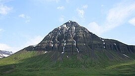
Búrfellshyrna (Icelandic pronunciation: [ˈpurˌfɛlsˌhɪ(r)tna] ) is a mountain in the Svarfaðardalur in northern Iceland. It is made of basaltic layers of Tertiary age. It reaches 1,091 meters at its highest peak. It is situated between the valleys of Búrfellsdalur and Grýtudalur. In Búrfellsdalur is the Búrfell Glacier, which exhibits what is sometimes referred to as a glacier surge. Farms surrounding Búrfellshyrna include Búrfell and Hæringsstaðir.
References
This Iceland location article is a stub. You can help Misplaced Pages by expanding it. |