Town in Western Australia
| Babakin Western Australia | |
|---|---|
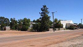
 Main street Main street | |
 | |
| Coordinates | 32°07′12″S 118°01′26″E / 32.12°S 118.024°E / -32.12; 118.024 |
| Population | 56 (SAL 2021) |
| Established | 1914 |
| Postcode(s) | 6428 |
| Area | 381.5 km (147.3 sq mi) |
| Location |
|
| LGA(s) | Shire of Bruce Rock |
| State electorate(s) | Central Wheatbelt |
| Federal division(s) | O'Connor |
Babakin is a small town located in the Wheatbelt region of Western Australia between the towns of Bruce Rock and Corrigin. At the 2021 census the population of Babakin was 56. Facilities in the town include a school, shop, hall and sporting facilities.
Babakin was a pastoral lease from 1873 to 1914 at this location, first taken up by C. Heal (Jnr). The name stems from a Noongar term for the dingo. The population increased with land grants given to returned servicemen after the Great War.
In 1926, Babakin joined with Ardath to field an Australian rules team in the Bruce Rock Football Association.
In 1932, the Wheat Pool of Western Australia announced that the town would have two grain elevators, each fitted with an engine, installed at the railway siding.
A very rare plant species inhabits the area—the Western Underground Orchid (Rhizanthella gardneri).
References
- Australian Bureau of Statistics (28 June 2022). "Babakin (suburb and locality)". Australian Census 2021 QuickStats. Retrieved 28 June 2022.

- "Country elevators". The West Australian. Perth: National Library of Australia. 6 July 1932. p. 10. Retrieved 6 April 2013.
- Higham, Geoffrey Where was That? an historical gazetteer of Western Australia. Geoproject Solutions, Winthrop, W.A: ISBN 0-646-44186-8.
- Lovell, Avon. Bruce Rock : a revised history Bruce Rock, W.A: Bruce Rock Shire Council, 1993. ISBN 0-646-05844-4.
- A rare and beautiful thing. Feature on Rhizanthella gardneri – in Lovell, pp. 167–174.
This article about a location in Western Australia is a stub. You can help Misplaced Pages by expanding it. |