Unincorporated community in New Jersey, United States
| Babbitt, North Bergen | |
|---|---|
| Unincorporated community | |
 | |
| Coordinates: 40°48′35″N 74°01′12″W / 40.80972°N 74.02000°W / 40.80972; -74.02000 | |
| Country | |
| State | |
| County | Hudson |
| Township | North Bergen |
| Elevation | 10 ft (3 m) |
| GNIS feature ID | 874439 |
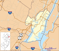
Babbitt is a neighborhood in North Bergen Township in Hudson County, in the U.S. state of New Jersey. The area, located west of Tonnelle Avenue within the New Jersey Meadowlands District, is home to light manufacturing, warehouses, transportation facilities, and part of the wetlands preservation area known as the Eastern Brackish Marsh.
Babbitt's Best Soap
The name is taken from the company that produced Babbitt's Best Soap, named after its founder, Benjamin T. Babbitt. In 1904 the company purchased a tract of 87 acres (35 ha) between Granton and Fairview, and in 1907 relocated from its former premises, a 22,000 square feet (2,000 m) facility on West Street in Lower Manhattan. to what was then one of the largest soap manufacturing plants in the world.
Granton Junction and Babbitt station


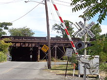
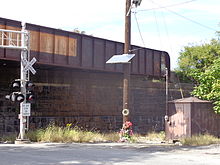
The West Shore Railroad, the Erie Railroad's Northern Branch, and the New York, Susquehanna, and Western (NYSW) all passed through the area running parallel to each other. Both Erie and NYSW maintained minor stations nearby 83rd Street, which crossed under the right-of-way of the West Shore. Granton Junction was located just south of the stations and was where NYSW and Erie converged after the latter had also passed under the West Shore. For a time Granton was busy railroad junction used by both the Erie and NYSW, which shared track and stations, including the Susquehanna Transfer. The name Granton comes from a former quarry that later was the site of an important fossil find of a phytosaur. Joint operations between the Erie and NYSW were controlled by GR Tower, which in 1959 was destroyed by fire, ending the relationship. Originally the soap works were outfitted with rail spurs by the NYSW, but the soap company shifted more and more of its traffic to trucks, and in 1909 (apparently in retaliation for the loss of business), anonymous agents of the railroad removed the spur after temporarily imprisoning the factory's workers in a boxcar to prevent any interference. In August 1922, a full Sunday evening Erie train heading south to Pavonia Terminal was struck by bombs thrown at it in what was considered an act of sabotage and an attempt to cause a collision.
CSX and HBLR Northern Branch 91st Street station
The West Shore subsequently became Conrail's River Line, and eventually the CSX River Subdivision which begins to the south at North Bergen Yard. Road access to its Little Ferry Yard is located in Babbitt.
The Hudson-Bergen Light Rail extension into eastern Bergen County known as the Northern Branch Corridor Project calls for the closure of the at-grade crossing at 83rd Street and creation of a new one at 85th Street.
A 91st Street (HBLR station) is planned.
See also
- List of neighborhoods in North Bergen, New Jersey
- List of New Jersey railroad junctions
- NYSW (passenger 1939-1966) map
- Northern Branch (NJ Transit) map
References
- ^ "Babbitt". Geographic Names Information System. United States Geological Survey, United States Department of the Interior.
- Locality Search Archived July 9, 2016, at the Wayback Machine, State of New Jersey. Accessed February 7, 2015.
- "USGS Map Name:Weehawken, NJ Map MRC: 40074G1". TopoQuest. Retrieved September 30, 2013.
- "Eastern Brackish Marsh". New Jersey Meadowlands Commission. Retrieved September 30, 2013.
- "To Abandon Down-Town Factory Site" (PDF). The New York Times. June 12, 1904. Retrieved September 30, 2013.
- "Big Downtown Sale" (PDF). The New York Times. April 17, 2010. Retrieved September 30, 2013.
- "In the Real Estate Field: New Babbitt Plant Mortgaged" (PDF). The New York Times. November 23, 1907. Retrieved September 30, 2013.
- "Appendix H: Historic Properties and Resources" (PDF). Northern Branch Corridor Project DEIS. New Jersey Transit. December 2011. Retrieved September 30, 2013.
- "List of Station Names and Numbers". Jersey City, New Jersey: Erie Railroad. May 1, 1916. Retrieved September 30, 2013.
- Sheppard, Bill (October 1977). "Granton Junction" (PDF). The Block Line. V (VIII). National Railway Historical Society (Tri-State Chapter). Archived from the original (PDF) on October 4, 2013. Retrieved October 2, 2013.
- Kaminski, Edward S. (2010), New York, Susquehanna and Western Railway in New Jersey, Arcadia Publishing, p. 9, ISBN 978-0-7385-7367-0
- Colbertz, Edwin (September 10, 1965). "A Phytosaur from North Bergen, New Jersey" (PDF). American Museum Novitates (2230). American Museum of Natural History. Retrieved September 30, 2013.
- Mohowski, Robert E. (2003), New York Susquehanna and Western, Johns Hopkins University Press, ISBN 9780801872228
- "Seize Factory Hands Remove Its Track" (PDF). The New York Times. May 25, 1909. Retrieved September 30, 2013.
- "Bombs Strike Two Cars" (PDF). The New York Times. August 14, 1922. Retrieved September 30, 2013.
- "1922: North Bergen Train Bombing". www.hudpost.com. Archived from the original on September 25, 2020.
- "85th Street at Grade Realignment & Closure of 83rd Street" (PDF). Northern Branch Corridor. New Jersey Transit. Retrieved September 30, 2013.
| Municipalities and communities of Hudson County, New Jersey, United States | ||
|---|---|---|
| County seat: Jersey City | ||
| Cities |  | |
| Borough | ||
| Towns | ||
| Townships | ||
| Regions | ||