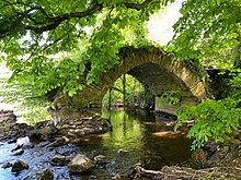
| Babe's Bridge | |
|---|---|
| Coordinates | 53°40′18″N 6°39′12″W / 53.67167°N 6.65333°W / 53.67167; -6.65333 |
| Crosses | River Boyne |
| Next upstream | Athlumley Bridge |
| Next downstream | Broadboyne Bridge |
| Characteristics | |
| Material | Stone |
| Traversable? | No |
| Location | |
Babe's Bridge is the remains of a 13th Century bridge over the River Boyne near Navan, County Meath, in Ireland. The southeast span is extant along with remains of some of the abutments in the river.
The remaining arch is owned by the heritage trust An Taisce - The National Trust for Ireland as part of the Boyne Navigation property.

Etymology
Babe's Bridge was named after the local Norman landowner John le Baub who owned the land where the bridge was built.
History
20th century
In the 1980's the Office of Public Works carried out an underpinning of the north abutment in concrete with assistance from Meath County Council.
21st century
In 2021 An Taisce and Meath County Council were awarded funding from the Department of Housing, Local Government and Heritage's Community Monuments Fund to carry out conservation studies for the structure.
Future
An Taisce is seeking funding to carry out conservation works.
External links
- Navan District Historical Society page on the bridge.
- An Taisce - The National Trust for Ireland page on the bridge
References
- "Navan Historical Society - Babes Bridge". www.navanhistory.ie. Retrieved 2022-02-25.
- "Boyne Navigation, Co. Meath". An Taisce - The National Trust For Ireland. 26 August 2019. Retrieved 2022-02-25.
- "Navan Historical Society - Babes Bridge". www.navanhistory.ie. Retrieved 2022-02-28.
- "The saving of Babe's BridgeSave the datesfor Heritage Week". Meath Chronicle. 30 April 2021. Retrieved 2022-02-28.
- "Minister Noonan announces 2021 Community Monuments Fund grants of over €4 million". www.gov.ie. 16 June 2021. Retrieved 2022-02-28.
- "Babe's Bridge". An Taisce - The National Trust For Ireland. 28 February 2022. Retrieved 2022-02-28.