| This article needs additional citations for verification. Please help improve this article by adding citations to reliable sources. Unsourced material may be challenged and removed. Find sources: "Baingoin County" – news · newspapers · books · scholar · JSTOR (October 2018) (Learn how and when to remove this message) |
| Baingoin County 班戈县 • དཔལ་མགོན་རྫོང་།Bangor | |
|---|---|
| County | |
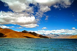
 Nam Tso Nam Tso | |
 Location of Baingoin County (red) in Nagqu City (yellow) and the Tibet Autonomous Region Location of Baingoin County (red) in Nagqu City (yellow) and the Tibet Autonomous Region | |
  | |
| Coordinates: 31°23′33″N 90°00′36″E / 31.3924°N 90.0100°E / 31.3924; 90.0100 | |
| Country | China |
| Autonomous region | Tibet |
| Prefecture-level city | Nagqu |
| County seat | Phukpa |
| Area | |
| • Total | 28,383 km (10,959 sq mi) |
| Population | |
| • Total | 39,309 |
| • Density | 1.4/km (3.6/sq mi) |
| Time zone | UTC+8 (China Standard) |
| Website | www |
| Baingoin County | |||||||||||
|---|---|---|---|---|---|---|---|---|---|---|---|
| Chinese name | |||||||||||
| Simplified Chinese | 班戈县 | ||||||||||
| Traditional Chinese | 班戈縣 | ||||||||||
| |||||||||||
| Tibetan name | |||||||||||
| Tibetan | དཔལ་མགོན་རྫོང་། | ||||||||||
| |||||||||||
Baingoin County (Tibetan: དཔལ་མགོན་རྫོང་།; Chinese: 班戈县), formerly Namru Dzong (Tibetan: གནམ་རུ་རྫོང), is a county within Nagqu of the Tibet Autonomous Region, China.
Baingoin County got the name from the Baingoin Co (Bangor Co) which is a lake in center of the county. The county lies between lakes Namtso and Siling.
Administrative divisions
The county is divided into 4 towns and 6 townships:
Climate
| Climate data for Baingoin, elevation 4,700 m (15,400 ft), (1991–2020 normals) | |||||||||||||
|---|---|---|---|---|---|---|---|---|---|---|---|---|---|
| Month | Jan | Feb | Mar | Apr | May | Jun | Jul | Aug | Sep | Oct | Nov | Dec | Year |
| Record high °C (°F) | 9.4 (48.9) |
9.5 (49.1) |
14.0 (57.2) |
14.2 (57.6) |
19.7 (67.5) |
23.2 (73.8) |
22.5 (72.5) |
20.6 (69.1) |
19.9 (67.8) |
17.2 (63.0) |
11.6 (52.9) |
15.1 (59.2) |
23.2 (73.8) |
| Mean daily maximum °C (°F) | −3.9 (25.0) |
−2.0 (28.4) |
1.6 (34.9) |
5.8 (42.4) |
10.1 (50.2) |
14.6 (58.3) |
15.2 (59.4) |
14.4 (57.9) |
12.6 (54.7) |
6.8 (44.2) |
1.3 (34.3) |
−1.9 (28.6) |
6.2 (43.2) |
| Daily mean °C (°F) | −10 (14) |
−7.8 (18.0) |
−4.3 (24.3) |
−0.5 (31.1) |
3.7 (38.7) |
8.2 (46.8) |
9.4 (48.9) |
8.8 (47.8) |
6.5 (43.7) |
0.5 (32.9) |
−5.1 (22.8) |
−8.3 (17.1) |
0.1 (32.2) |
| Mean daily minimum °C (°F) | −16.3 (2.7) |
−13.7 (7.3) |
−10.1 (13.8) |
−6.3 (20.7) |
−2.1 (28.2) |
2.6 (36.7) |
4.6 (40.3) |
4.1 (39.4) |
1.8 (35.2) |
−4.7 (23.5) |
−10.9 (12.4) |
−14.8 (5.4) |
−5.5 (22.1) |
| Record low °C (°F) | −42.9 (−45.2) |
−37.6 (−35.7) |
−30.5 (−22.9) |
−19.6 (−3.3) |
−15.2 (4.6) |
−7.7 (18.1) |
−6.6 (20.1) |
−4.6 (23.7) |
−9.2 (15.4) |
−21.7 (−7.1) |
−39.4 (−38.9) |
−42.7 (−44.9) |
−42.9 (−45.2) |
| Average precipitation mm (inches) | 2.6 (0.10) |
2.3 (0.09) |
3.7 (0.15) |
6.5 (0.26) |
25.4 (1.00) |
59.8 (2.35) |
92.2 (3.63) |
83.5 (3.29) |
56.0 (2.20) |
10.3 (0.41) |
2.2 (0.09) |
1.9 (0.07) |
346.4 (13.64) |
| Average precipitation days (≥ 0.1 mm) | 3.9 | 3.7 | 4.5 | 6.9 | 12.3 | 17.2 | 21.0 | 20.3 | 16.6 | 6.0 | 2.6 | 2.7 | 117.7 |
| Average snowy days | 6.1 | 6.0 | 8.2 | 10.9 | 16.3 | 7.9 | 0.8 | 1.3 | 7.4 | 8.7 | 4.4 | 4.7 | 82.7 |
| Average relative humidity (%) | 30 | 28 | 29 | 36 | 46 | 55 | 63 | 65 | 61 | 43 | 33 | 29 | 43 |
| Mean monthly sunshine hours | 227.3 | 210.3 | 241.3 | 246.9 | 262.2 | 239.3 | 202.7 | 195.2 | 220.2 | 261.5 | 247.5 | 240.7 | 2,795.1 |
| Percent possible sunshine | 70 | 67 | 64 | 63 | 61 | 57 | 47 | 48 | 60 | 75 | 79 | 77 | 64 |
| Source 1: China Meteorological Administration | |||||||||||||
| Source 2: Météo Climat (extremes) | |||||||||||||
References
- "那曲市第七次全国人口普查主要数据公报" (in Chinese). Statistics Bureau of Nagqu. 2021-07-09.
- 中国气象数据网 – WeatherBk Data (in Simplified Chinese). China Meteorological Administration. Retrieved 27 September 2023.
- 中国气象数据网 (in Simplified Chinese). China Meteorological Administration. Retrieved 27 September 2023.
- "Weather extremes for Baingoin". Météo Climat. Retrieved 11 November 2019.
| County-level divisions of Tibet Autonomous Region | |||||||||||||
|---|---|---|---|---|---|---|---|---|---|---|---|---|---|
| Lhasa (capital) | |||||||||||||
| Prefecture-level cities |
| ||||||||||||
| Prefecture |
| ||||||||||||
| ** Southern portions of these counties are claimed by the People's Republic of China as part of the South Tibet area, but are administered by India. | |||||||||||||
| Nagqu | ||
|---|---|---|
| District | Seni |  |
| Counties | ||
| Towns and villages |
| |
| Geography | ||
| Sciences | ||
This Nagqu Prefecture, Tibet location article is a stub. You can help Misplaced Pages by expanding it. |