| Bairi County དཔའ་རིས་རྫོང་ · 天祝县Tianzhu | |
|---|---|
| Autonomous county | |
| དཔའ་རིས་བོད་རང་སྐྱོང་རྫོང༌། · 天祝藏族自治县 Bairi Tibetan Autonomous County | |
 | |
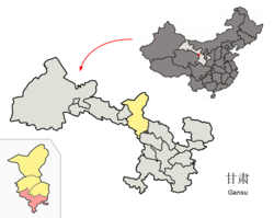
 Bairi County (red) within Wuwei City (yellow) and Gansu Bairi County (red) within Wuwei City (yellow) and Gansu | |
  | |
| Coordinates: 36°58′18″N 103°08′31″E / 36.9718°N 103.1419°E / 36.9718; 103.1419 | |
| Country | China |
| Province | Gansu |
| Prefecture-level city | Wuwei |
| County seat | Rabgyai (Huazangsi) |
| Area | |
| • Total | 7,149 km (2,760 sq mi) |
| Highest elevation | 4,874 m (15,991 ft) |
| Lowest elevation | 2,040 m (6,690 ft) |
| Population | |
| • Total | 151,031 |
| • Density | 21/km (55/sq mi) |
| Time zone | UTC+8 (China Standard) |
| Postal code | 733200 |
| Website | www |
| Bairi Tibetan Autonomous County | |||||||
|---|---|---|---|---|---|---|---|
| Chinese name | |||||||
| Simplified Chinese | 天祝藏族自治县 | ||||||
| Traditional Chinese | 天祝藏族自治縣 | ||||||
| |||||||
| Alternative Chinese name | |||||||
| Simplified Chinese | 华锐 | ||||||
| Traditional Chinese | 華銳 | ||||||
| |||||||
| Tibetan name | |||||||
| Tibetan | དཔའ་རིས་བོད་རང་སྐྱོང་རྫོང༌། | ||||||
| |||||||
Bairi Tibetan Autonomous County (Tibetan: དཔའ་རིས་བོད་རང་སྐྱོང་རྫོང༌།), also known as Tianzhu from its Chinese name (Chinese: 天祝藏族自治县), is in the prefecture-level city of Wuwei in the central part of Gansu province, China, bordering Qinghai province to the south and west. It has an area of 7,147 km (2,759 sq mi) and approximately 230,000 inhabitants (2003). Its administrative seat is Rabgyai Town (Huazangsi).
Name
The Chinese name "Tianzhu" was named by a Tibetan lama Luo Haoxue (罗好学) in 1936, deriving from the combination of "Tiantang" (天堂寺, aka Chortentang Monastery) and "Zhugong" (祝贡寺, aka Drigung Monastery), the Chinese translation of the two largest lamaseries in the county.
The Tibetan name Bairi (དཔའ་རིས།) is pronounced Bairi in Standard Tibetan, and pronounced Hwari in the local Amdo Tibetan and Huarui (华锐) in Chinese.
An alternative Tibetan name is Tenzhu (ཐེན་ཀྲུའུ།), which is a transcription of the Chinese name Tianzhu.
History
The county was established as the Tianzhu District of Yongdeng County in 1949, but became an autonomous county of Wuwei in the next year. In 1955, Tianzhu was moved under the administration of Zhangye as the first autonomous county in China. Between 1958 and 1961, Gulang County was part of Tianzhu. In 1961 the county was placed under Wuwei again.
Administrative divisions
Bairi Tibetan Autonomous County is divided to 14 towns, 5 townships.
| Name | Simplified Chinese | Hanyu Pinyin | Tibetan | Wylie | Administrative division code | |
|---|---|---|---|---|---|---|
| Towns | ||||||
| Rabgyai Town (Huazangsi) |
华藏寺镇 | Huázàngsì Zhèn | རབ་རྒྱས་གྲོང་རྡལ། | rab rgyas grong rdal | 620623100 | |
| Zhaxilung Town (Dachaigou) |
打柴沟镇 | Dǎcháigōu Zhèn | བཀྲ་ཤིས་ལུང་གྲོང་རྡལ། | bkra shis lung grong rdal | 620623101 | |
| Tawain Town (Anyuan) |
安远镇 | Ānyuǎn Zhèn | ཏཱ་བན་གྲོང་རྡལ། | tā ban grong rdal | 620623102 | |
| Kêsangnyagkai Town (Tanshanling) |
炭山岭镇 | Tànshānlǐng Zhèn | ཁེས་བཟང་ཉག་གའི་གྲོང་རྡལ། | khes bzang nyag gaʼi grong rdal | 620623103 | |
| Pachi Town (Haxi) |
哈溪镇 | Hāxī Zhèn | ཕ་ཁྲི་གྲོང་རྡལ། | pha khri grong rdal | 620623104 | |
| Sêrzü Town (Saishisi) |
赛什斯镇 | Sàishísī Zhèn | སེར་རྩུད་གྲོང་རྡལ། | ser rtsud grong rdal | 620623105 | |
| Yarlung Town (Shimen) |
石门镇 | Shímén Zhèn | ཡར་ལུང་གྲོང་རྡལ། | yar lung grong rdal | 620623106 | |
| Daglung Town (Songshan) |
松山镇 | Sōngshān Zhèn | སྟག་ལུང་གྲོང་རྡལ། | stag lung grong rdal | 620623107 | |
| Qoidêntang Town (Tiantang) |
天堂镇 | Tiāntáng Zhèn | མཆོད་རྟེན་ཐང་གྲོང་རྡལ། | mchod rten thang grong rdal | 620623108 | |
| Torxi Town (Duoshi) |
朵什镇 | Duǒshí Zhèn | དོར་ཞི་གྲོང་རྡལ། | dor zhi grong rdal | 620623109 | |
| Xamar Town (Xidatan) |
西大滩镇 | Xīdàtān Zhèn | ཞྭ་དམར་གྲོང་རྡལ། | zhwa dmar grong rdal | 620623110 | |
| Zhaxiquglung Town (Zhuaxixiulong) |
抓喜秀龙镇 | Zhuāxǐxiùlóng Zhèn | བཀྲ་ཤིས་ཕྱུག་ལུང་གྲོང་རྡལ། | bkra shis phyug lung grong rdal | 620623111 | |
| Gyayag Town (Dahonggou) |
大红沟镇 | Dàhónggōu Zhèn | རྒྱ་ཡག་གྲོང་རྡལ། | rgya yag grong rdal | 620623112 | |
| Sabda'gyai Town (Qilian) |
祁连镇 | Qílián Zhèn | སྲབ་མདའ་བརྒྱད་གྲོང་རྡལ། | srab mda' brgyad grong rdal | 620623113 | |
| Townships | ||||||
| Dongpoin Township (Dongping) |
东坪乡 | Dōngpíng Xiāng | སྟོང་བོན་ཞང་། | stong bon zhang | 620623201 | |
| Sêralung Township (Sailalong) |
赛拉隆乡 | Sàilālóng Xiāng | སེ་ར་ལུང་ཞང་། | se ra lung zhang | 620623202 | |
| Gyiyangtang Township (Dongdatan) |
东大滩乡 | Dōngdàtān Xiāng | སྐྱིད་ཡངས་ཐང་ཞང་། | skyid yangs thang zhang | 620623203 | |
| Horxugkya Township (Maozang) |
毛藏乡 | Máozàng Xiāng | ཧོར་ཤུག་ཁྱ་ཞང་། | hor shug khya zhang | 620623208 | |
| Dainma Township (Danma) |
旦马乡 | Dànmǎ Xiāng | འདན་མ་ཞང་། | 'dan ma zhang | 620623210 | |
- Others
- Tianzhu Building Material Factory (天祝建材厂)
- Tianzhu Coal and Electricity Company (天祝煤电公司)
Geography
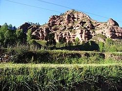
The county is mountainous, being located at the tripoint of the Tibet Plateau, the Loess Plateau and the Inner Mongolia Plateau, with elevations ranging from 2040 m to 4874 m. It is divided into the watersheds of the Shiyang River and the Yellow River and crossed by the Wushao Mountain. South of the Wushao Mountain, the climate is continental and north of it, the climate is semi-arid. The land is mostly covered by grasslands and forests.
Climate
| Climate data for Bairi, elevation 2,485 m (8,153 ft), (1991–2020 normals) | |||||||||||||
|---|---|---|---|---|---|---|---|---|---|---|---|---|---|
| Month | Jan | Feb | Mar | Apr | May | Jun | Jul | Aug | Sep | Oct | Nov | Dec | Year |
| Mean daily maximum °C (°F) | −0.6 (30.9) |
2.4 (36.3) |
7.8 (46.0) |
13.1 (55.6) |
17.0 (62.6) |
20.7 (69.3) |
22.9 (73.2) |
21.7 (71.1) |
16.7 (62.1) |
11.9 (53.4) |
6.0 (42.8) |
0.6 (33.1) |
11.7 (53.0) |
| Daily mean °C (°F) | −10.9 (12.4) |
−7.2 (19.0) |
−1.0 (30.2) |
5.0 (41.0) |
9.6 (49.3) |
14.0 (57.2) |
16.0 (60.8) |
14.7 (58.5) |
10.0 (50.0) |
4.1 (39.4) |
−3.0 (26.6) |
−9.7 (14.5) |
3.5 (38.2) |
| Mean daily minimum °C (°F) | −17.6 (0.3) |
−13.9 (7.0) |
−7.6 (18.3) |
−2.2 (28.0) |
2.5 (36.5) |
7.4 (45.3) |
9.4 (48.9) |
9.0 (48.2) |
4.9 (40.8) |
−1.3 (29.7) |
−8.6 (16.5) |
−16.1 (3.0) |
−2.8 (26.9) |
| Average precipitation mm (inches) | 2.7 (0.11) |
5.1 (0.20) |
6.8 (0.27) |
17.5 (0.69) |
43.9 (1.73) |
59.5 (2.34) |
64.9 (2.56) |
90.1 (3.55) |
62.8 (2.47) |
26.2 (1.03) |
7.3 (0.29) |
2.2 (0.09) |
389 (15.33) |
| Average precipitation days (≥ 0.1 mm) | 3.8 | 5.5 | 5.3 | 7.6 | 11.4 | 13.8 | 13.4 | 15.2 | 17.4 | 9.9 | 5.8 | 4.4 | 113.5 |
| Average snowy days | 6.1 | 8.2 | 6.7 | 5.8 | 2.2 | 0 | 0 | 0 | 0.5 | 4.6 | 7.5 | 6.0 | 47.6 |
| Average relative humidity (%) | 53 | 52 | 48 | 48 | 53 | 58 | 65 | 71 | 76 | 70 | 64 | 55 | 59 |
| Mean monthly sunshine hours | 228.7 | 216.6 | 242.6 | 232.2 | 230.4 | 202.6 | 211.5 | 185.3 | 166.6 | 204.3 | 214.7 | 226.2 | 2,561.7 |
| Percent possible sunshine | 74 | 70 | 65 | 59 | 53 | 46 | 48 | 45 | 46 | 60 | 71 | 76 | 59 |
| Source: China Meteorological Administration | |||||||||||||
| Climate data for Wuqiaoling, Bairi (elevation 3,045 m (9,990 ft), 1991–2020 normals) | |||||||||||||
|---|---|---|---|---|---|---|---|---|---|---|---|---|---|
| Month | Jan | Feb | Mar | Apr | May | Jun | Jul | Aug | Sep | Oct | Nov | Dec | Year |
| Mean daily maximum °C (°F) | −4.9 (23.2) |
−2.5 (27.5) |
1.5 (34.7) |
7.0 (44.6) |
11.2 (52.2) |
15.0 (59.0) |
17.2 (63.0) |
16.2 (61.2) |
11.9 (53.4) |
6.6 (43.9) |
1.4 (34.5) |
−3.2 (26.2) |
6.5 (43.6) |
| Daily mean °C (°F) | −11.3 (11.7) |
−9.1 (15.6) |
−4.7 (23.5) |
1.2 (34.2) |
5.7 (42.3) |
10.0 (50.0) |
12.3 (54.1) |
11.1 (52.0) |
6.7 (44.1) |
0.9 (33.6) |
−4.8 (23.4) |
−9.5 (14.9) |
0.7 (33.3) |
| Mean daily minimum °C (°F) | −16.1 (3.0) |
−13.9 (7.0) |
−9.1 (15.6) |
−3.4 (25.9) |
1.0 (33.8) |
5.6 (42.1) |
8.0 (46.4) |
7.1 (44.8) |
3.0 (37.4) |
−2.9 (26.8) |
−9.2 (15.4) |
−14.3 (6.3) |
−3.7 (25.4) |
| Average precipitation mm (inches) | 3.0 (0.12) |
5.2 (0.20) |
11.7 (0.46) |
19.1 (0.75) |
41.9 (1.65) |
70.3 (2.77) |
91.0 (3.58) |
93.2 (3.67) |
66.4 (2.61) |
22.6 (0.89) |
4.9 (0.19) |
2.0 (0.08) |
431.3 (16.97) |
| Average precipitation days (≥ 0.1 mm) | 5.4 | 8.0 | 11.5 | 11.4 | 14.1 | 14.7 | 16.6 | 17.7 | 17.0 | 11.7 | 5.6 | 4.4 | 138.1 |
| Average snowy days | 9.2 | 11.3 | 15.7 | 13.8 | 11.2 | 1.4 | 0.1 | 0.4 | 4.4 | 13.0 | 8.9 | 7.9 | 97.3 |
| Average relative humidity (%) | 49 | 53 | 55 | 54 | 58 | 61 | 68 | 73 | 74 | 65 | 52 | 47 | 59 |
| Mean monthly sunshine hours | 232.4 | 221.9 | 239.7 | 235.1 | 235.5 | 211.8 | 213.4 | 193.1 | 176.3 | 218.4 | 237.0 | 236.2 | 2,650.8 |
| Percent possible sunshine | 75 | 72 | 64 | 59 | 53 | 48 | 48 | 47 | 48 | 64 | 79 | 80 | 61 |
| Source: China Meteorological Administration | |||||||||||||
Transport
- China National Highway 312
- Lanzhou–Xinjiang Railway crosses the county, with a station (Tianzhu) in the county seat. With the construction of the Wushaoling Tunnel under the Wushao Mountain Range (Wushaoling), about the half of the section of the main track of this railway within this county is actually underground.
Ethnic groups in Tianzhu, 2000 census
| Nationality | Population | Percentage |
|---|---|---|
| Han | 139,190 | 62.88% |
| Tibetan | 66,125 | 29.87% |
| Tu | 12,633 | 5.71% |
| Hui | 1,986 | 0.9% |
| Mongol | 961 | 0.43% |
| Manchu | 213 | 0.1% |
| Dongxiang | 90 | 0.04% |
| Uyghur | 40 | 0.02% |
| Miao | 23 | 0.01% |
| Others | 86 | 0.04% |
References
- "武威市第七次全国人口普查公报" (in Chinese). Government of Wuwei. 2021-05-27.
- "天祝旅游网". Archived from the original on 2013-02-04. Retrieved 2012-01-19.
- ^ "甘肃·天祝 - 走进天祝". www.gstianzhu.gov.cn. Retrieved 2020-12-31.
- ^ "天祝藏族自治县". 13 July 2004.
- 2022年统计用区划代码和城乡划分代码 (in Chinese). National Bureau of Statistics of the People's Republic of China.
- ^ 中国气象数据网 – WeatherBk Data (in Simplified Chinese). China Meteorological Administration. Retrieved 24 September 2023.
- 中国气象数据网 (in Simplified Chinese). China Meteorological Administration. Retrieved 24 September 2023.
- 中国气象数据网 (in Simplified Chinese). China Meteorological Administration. Retrieved 24 September 2023.
Further reading
- A. Gruschke: The Cultural Monuments of Tibet’s Outer Provinces: Amdo - Volume 2. The Gansu and Sichuan Parts of Amdo, White Lotus Press, Bangkok 2001. ISBN 974-480-049-6
- Tsering Shakya: The Dragon in the Land of Snows. A History of Modern Tibet Since 1947, London 1999, ISBN 0-14-019615-3
| Tibetan-designated autonomous areas in China | |||||||||
|---|---|---|---|---|---|---|---|---|---|
| Regions |
|  | |||||||
| Prefectures and counties |
| ||||||||
This Gansu location article is a stub. You can help Misplaced Pages by expanding it. |