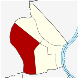
| Bang Khun Si แขวงบางขุนศรี | |
|---|---|
| Khwaeng | |
 Bang Khun Si during construction of MRT Blue Line elevated subway front of Makro Charan Sanit Wong on Charan Sanit Wong Road (opposite side is Ban Chang Lo) Bang Khun Si during construction of MRT Blue Line elevated subway front of Makro Charan Sanit Wong on Charan Sanit Wong Road (opposite side is Ban Chang Lo) | |
 Location in Bangkok Noi District Location in Bangkok Noi District | |
| Country | |
| Province | Bangkok |
| Khet | Bangkok Noi |
| Area | |
| • Total | 4.360 km (1.683 sq mi) |
| Population | |
| • Total | 31,689 |
| Time zone | UTC+7 (ICT) |
| Postal code | 10700 |
| TIS 1099 | 102007 |
Bang Khun Si (Thai: บางขุนศรี, pronounced [bāːŋ kʰǔn sǐː]) is a khwaeng (subdistrict) of Bangkok Noi District, in Bangkok, Thailand. In 2019, it had a total population of 31,689 people.
Naming
The name is derived from a canal that runs through the west area, Khlong Bang Khun Si, also known as Khlong Chak Phra.
Geography
Bang Khun Si covers the central-southwest area of Bangkok Noi, with a total area of 4.360 km (1.683 mi), regarded as the largest subdistrict of Bangkok Noi.
The area is bordered by neighbouring subdistricts (from north clockwise): Bang Khun Non in its district (Southern Railway Line is borderline), Siri Rat and Ban Chang Lo in its district (Charan Sanit Wong Road is a borderline), Wat Tha Phra in Bangkok Yai District (Khlong Mon is a borderline), Khuha Sawan in Phasi Charoen District (Khlong Bang Chueak Nang is a borderline), Khlong Chak Phra in Taling Chan District (Khlong Chak Phra is a borderline), respectively.
References
- Administrative Strategy Division, Strategy and Evaluation Department, Bangkok Metropolitan Administration (2021). สถิติกรุงเทพมหานครประจำปี 2563 [Bangkok Statistics 2020] (PDF) (in Thai). Retrieved 27 November 2021.
{{cite web}}: CS1 maint: multiple names: authors list (link) - "Population statistics 2019" (in Thai). Department of Provincial Administration. Retrieved 2020-10-08.,
This article related to the city of Bangkok, Thailand is a stub. You can help Misplaced Pages by expanding it. |