| Banholt Tebannet | |
|---|---|
| Village | |
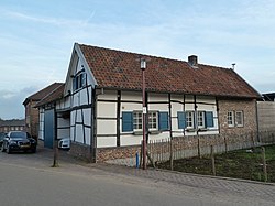
 Farm in Banholt Farm in Banholt | |
  | |
| Coordinates: 50°47′23″N 5°48′34″E / 50.78972°N 5.80944°E / 50.78972; 5.80944 | |
| Country | Netherlands |
| Province | Limburg (Netherlands) |
| Municipality | Eijsden-Margraten |
| Area | |
| • Total | 4.55 km (1.76 sq mi) |
| Elevation | 173 m (568 ft) |
| Population | |
| • Total | 1,015 |
| • Density | 220/km (580/sq mi) |
| Time zone | UTC+1 (CET) |
| • Summer (DST) | UTC+2 (CEST) |
| Postal code | 6262 |
| Dialing code | 043 |
| Major roads | N278 |
Banholt (Limburgish: Tebannet) is a village in the Dutch province of Limburg. It is part of the municipality of Eijsden-Margraten and lies about 10 km southeast of Maastricht.
The village was first mentioned in 1294 or 1295 as Bannoyt. Banholt which developed in the Middle Ages on the plateau of Margraten. In the 18th century, it became a road village.
The Catholic St Gerlachus Church is a three aisled church with wide church which was constructed between 1874 and 1876. Banholt was home to 471 people in 1840.
Gallery
References
- ^ "Kerncijfers wijken en buurten 2021". Central Bureau of Statistics. Retrieved 24 April 2022.
- "Postcodetool for 6262NA". Actueel Hoogtebestand Nederland (in Dutch). Het Waterschapshuis. Retrieved 24 April 2022.
- "Banholt - (geografische naam)". Etymologiebank (in Dutch). Retrieved 24 April 2022.
- ^ Sabine Broekhoven, & Ronald Stenvert (2003). Banholt (in Dutch). Zwolle: Waanders. ISBN 90 400 9623 6. Retrieved 24 April 2022.
- "Banholt". Plaatsengids (in Dutch). Retrieved 24 April 2022.
| Populated places in the municipality of Eijsden-Margraten | |
|---|---|
| Villages | |
| Hamlets | |
| List of cities, towns and villages in Limburg (Netherlands) | |
This Dutch Limburg location article is a stub. You can help Misplaced Pages by expanding it. |


