| Baril Peak | |
|---|---|
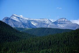
 Baril Peak (left), Mt. Cornwell (right), from NE Baril Peak (left), Mt. Cornwell (right), from NE | |
| Highest point | |
| Elevation | 3,000 m (9,800 ft) |
| Prominence | 283 m (928 ft) |
| Coordinates | 50°17′58″N 114°45′23″W / 50.29944°N 114.75639°W / 50.29944; -114.75639 |
| Geography | |
   | |
| Country | Canada |
| Provinces | Alberta and British Columbia |
| Parent range | High Rock Range |
| Topo map | NTS 82J7 Mount Head |
| Climbing | |
| First ascent | 1915 Interprovincial Boundary Commission |
Baril Peak is located on the border of Alberta and British Columbia on the Continental Divide. It was named in 1918 after Conrad M.L. Baril, a Dominion surveyor killed in World War I.
The mountain is composed of sedimentary rock laid down during the Precambrian to Jurassic periods. Formed in shallow seas, this sedimentary rock was pushed east and over the top of younger rock during the Laramide orogeny.
See also
- List of peaks on the Alberta–British Columbia border
- List of mountains of Alberta
- Mountains of British Columbia
References
- ^ "Baril Peak". Bivouac.com. Retrieved 2019-07-10.
- ^ "Baril Peak". Geographical Names Data Base. Natural Resources Canada. Retrieved 2019-07-10.
- ^ "Baril Peak". cdnrockiesdatabases.ca. Retrieved 2019-07-10.
- Boles, Glen W.; Laurilla, Roger W.; Putnam, William L. (2006). Canadian Mountain Place Names. Vancouver: Rocky Mountain Books. p. 37. ISBN 978-1-894765-79-4.
- Gadd, Ben (2008). Geology of the Rocky Mountains and Columbias.
External links
This article related to a mountain, mountain range, or peak in Canada is a stub. You can help Misplaced Pages by expanding it. |
This Alberta's Rockies location article is a stub. You can help Misplaced Pages by expanding it. |
This article about a location in the Interior of British Columbia, Canada is a stub. You can help Misplaced Pages by expanding it. |