Municipality in Southeast, Brazil
| Piracaia | |
|---|---|
| Municipality | |
 Igreja das Almas in Piracaia Igreja das Almas in Piracaia | |
 Flag Flag Coat of arms Coat of arms | |
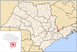
 Location in São Paulo state Location in São Paulo state | |
 | |
| Coordinates: 23°3′14″S 46°21′29″W / 23.05389°S 46.35806°W / -23.05389; -46.35806 | |
| Country | Brazil |
| Region | Southeast |
| State | São Paulo |
| Area | |
| • Total | 386 km (149 sq mi) |
| Population | |
| • Total | 27,462 |
| • Density | 71/km (180/sq mi) |
| Time zone | UTC−3 (BRT) |
Piracaia is a municipality in the state of São Paulo in Brazil. The population is 27,462 (2020 est.) in an area of 386 km². The elevation is 792 m. The municipality was established in 1859 as Santo Antônio da Cachoeira, and its name was changed to Piracaia on 20 August 1906.
Media
In telecommunications, the city was served by Companhia Telefônica Brasileira until 1973, when Telecomunicações de São Paulo took over.
See also
References
- IBGE 2020
- Instituto Brasileiro de Geografia e Estatística
- IBGE, history
- "Creation of Telesp – April 12, 1973". www.imprensaoficial.com.br (in Portuguese). Retrieved 27 May 2024.
This geographical article relating to the state of São Paulo is a stub. You can help Misplaced Pages by expanding it. |