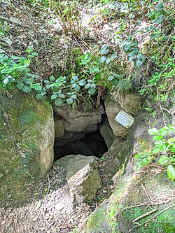
| Bath Swallet | |
|---|---|
 Bath Swallet entrance Bath Swallet entrance | |
 | |
| Location | Burrington Combe, Somerset, UK |
| OS grid | ST47255845 |
| Coordinates | 51°19′22″N 2°45′30″W / 51.32269°N 2.75838°W / 51.32269; -2.75838 |
| Depth | 37 metres (121 ft) |
| Length | 76 metres (249 ft) |
| Geology | Limestone |
| Entrances | 2 (Rod's Pot) |
| Hazards | Fall hazard |
| Access | Free |
| Registry | Mendip Cave Registry |
Bath Swallet is a karst cave in Burrington Combe on the Mendip Hills in Somerset, England.
On Wednesday 19 September 2007 members of the Wessex Cave Club and Cheddar Caving Club succeeded in connecting Bath Swallet and Rod's Pot. It had been anticipated that the upward dig in Bath would connect with the end of 'Purple Passage' in Rod's Pot and this proved to be true. This creates what is probably Mendip's third longest through trip.
See also
References
- "Bath Swallet". Mendip Cave Registry & Archive.
- Sparrow, Andy. "Bath Swallet and Rod's Pot connected". UKcaving.com. Retrieved 11 May 2020.
This article about a cave is a stub. You can help Misplaced Pages by expanding it. |
This Somerset location article is a stub. You can help Misplaced Pages by expanding it. |