| Beaufortain Massif | |
|---|---|
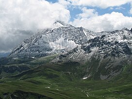
 The Pointe de la Terrasse as seen from the Rocher du Vent The Pointe de la Terrasse as seen from the Rocher du Vent | |
| Highest point | |
| Elevation | 2,995 m (9,826 ft) |
| Prominence | 1,028 m (3,373 ft) |
| Coordinates | 45°41′10.71″N 6°34′8.63″E / 45.6863083°N 6.5690639°E / 45.6863083; 6.5690639 |
| Naming | |
| Native name | Massif du Beaufortain (French) |
| Geography | |
 | |
| Parent range | French Alps |
The Beaufortain Massif (French: Massif du Beaufortain, pronounced [masif dy bofɔʁtɛ̃]) is a massif of the French Alps that straddles the southeastern departments of Savoie and Haute-Savoie, in the historical region of Savoy.
It is bounded by the Arly river to the northwest, the Bon Nant [fr] to the northeast, as well as the Isère river as it runs through the Tarentaise Valley to the south. It is also crossed by the Dorinet and Doron de Beaufort [fr] rivers, in addition to their tributaries, from northeast to southwest, at Beaufort level.
It is surrounded by the Aravis Range, the Bauges Range, the Lauzière massif, the Vanoise massif and the Mont-Blanc massif.
Peaks
| Name | Elevation |
|---|---|
| Roignais | 2,995 m (9,826 ft) |
| Combe Neuve | 2,961 m (9,715 ft) |
| Aiguille du Grand Fond | 2,920 m (9,580 ft) |
| Pointe de la Terrasse | 2,881 m (9,452 ft) |
| Grande Paréi | 2,725 m (8,940 ft) |
| Pierra Menta | 2,714 m (8,904 ft) |
| Aiguilles de la Penaz | 2,688 m (8,819 ft) |
| Grand Mont | 2,686 m (8,812 ft) |
| Crêt du Rey | 2,633 m (8,638 ft) |
| Tête de la Cicle | 2,552 m (8,373 ft) |
| Crête des Gittes | 2,538 m (8,327 ft) |
| Mont Coin | 2,539 m (8,330 ft) |
| Mont Joly | 2,525 m (8,284 ft) |
| Aiguille Croche | 2,487 m (8,159 ft) |
| Pointe de la Grande Journée | 2,462 m (8,077 ft) |
| Mont Mirantin | 2,460 m (8,070 ft) |
| Roche Pourrie | 2,037 m (6,683 ft) |
| Mont d'Arbois | 1,833 m (6,014 ft) |
See also
References
- ^ "Le Roignais - peakbagger.com". peakbagger.com. Retrieved 9 March 2015.
- "Haute Route du Beaufortain". Savoie Mont Blanc.
Further reading
- Hagenmuller, Christophe (2006). Les plus belles traces du Beaufortain. Naturalpes. ISBN 295278700X.
- Manon, Martial (2002). Panorama du Beaufortain. Les Savoisiennes. Montmélian: La Fontaine De Siloe. ISBN 2842062051.
| Western Alps | ||||||
|---|---|---|---|---|---|---|
| Sections (as per SOIUSA) |
|  | ||||
| Other ranges | ||||||
| Massifs | ||||||