Municipality in Northeast, Brazil
| Belém de São Francisco | |
|---|---|
| Municipality | |
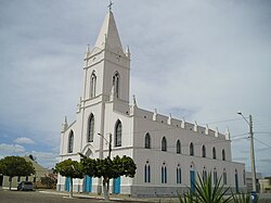
 Parish of Menino Deus church Parish of Menino Deus church | |
 Flag Flag Coat of arms Coat of arms | |
 Location of Belém de São Francisco in Pernambuco Location of Belém de São Francisco in Pernambuco | |
  | |
| Coordinates: 08°45′28″S 38°57′50″W / 8.75778°S 38.96389°W / -8.75778; -38.96389 | |
| Country | |
| Region | Northeast |
| State | |
| Founded | 7 May 1903 |
| Government | |
| • Mayor | Gustavo Henrique Granja Caribé (MDB) |
| • Vice Mayor | Batista Cícero de Assis (AVANTE) |
| Area | |
| • Total | 1,830.8 km (706.9 sq mi) |
| Elevation | 305 m (1,001 ft) |
| Population | |
| • Total | 18,301 |
| • Density | 10/km (30/sq mi) |
| Demonym | Belenense (Brazilian Portuguese) |
| Time zone | UTC-03:00 (Brasília Time) |
| Postal code | 56440-000 |
| HDI (2010) | 0.642 – medium |
| Website | belemdosaofrancisco.pe.gov.br |
Belém de São Francisco (Bethlehem of San Francisco) is a city in the state of Pernambuco, Brazil. The population in 2020, according with IBGE was 20,730 and the area is 1830.81 km².
Geography
- State - Pernambuco
- Region - São Francisco Pernambucano
- Boundaries - Salgueiro (N); Bahia state (S); Itacuruba and Carnaubeira da Penha (E); Cabrobó (W)
- Area - 1830.81 km²
- Elevation - 305 m
- Hydrography - Pajeú and Terra Nova rivers
- Vegetation - Caatinga hiperxerófila.
- Climate - Semi arid ( Sertão) hot and dry
- Annual average temperature - 26.2 c
- Distance to Recife - 456 km
Economy
The main economic activities in Belém de São Francisco are based in general commerce and agribusiness, especially farming of goats, sheep, cattle, donkeys and chickens; and plantations of mangoes, onions, and rice.
Economic Indicators
| Population | GDP x(1000 R$). | GDP pc (R$) | PE |
|---|---|---|---|
| 21.342 | 78.820 | 3.836 | 0.13% |
Economy by Sector 2006
| Primary sector | Secondary sector | Service sector |
|---|---|---|
| 20.04% | 9.43% | 70.54% |
Health Indicators
| HDI (2000) | Hospitals (2007) | Hospitals beds (2007) | Children's Mortality every 1000 (2005) |
|---|---|---|---|
| 0.669 | 1 | 48 | 22.4 |
Notable people
- Sérgia Ribeiro da Silva (1915-1994), a prominent cangaçeira
See also
References
- ^ "Belém do São Francisco". Instituto Brasileiro de Geografia e Estatística. Instituto Brasileiro de Geografia e Estatística. Retrieved 22 August 2024.
- "1 Introdução Breve Histórico de Belém do São Francisco" (PDF). Divulgação de Candidaturas e Contas Eleitorais. Tribunal Superior Eleitoral. Retrieved 22 August 2024.
- ^ "Prefeito e vereadores de Belém do São Francisco tomam posse; veja lista de eleitos". globo.com. globo.com. Retrieved 22 August 2024.
- "Código Postal Belém do São Francisco/PE - Brasil". Código Postal. Código Postal. Retrieved 26 August 2024.
- IBGE 2020
- Belém de São Francisco 2007 GDP IBGE page 29 Archived 4 March 2016 at the Wayback Machine
- PE State site - City by city profile
| Capital: Recife | ||||||||||||||
| Mesoregion Agreste Pernambucano |
|  | ||||||||||||
| Mesoregion Mata Pernambucana |
| |||||||||||||
| Mesoregion Metropolitana de Recife |
| |||||||||||||
| Mesoregion Sao Francisco Pernambucano |
| |||||||||||||
| Mesoregion Sertão Pernambucano |
| |||||||||||||
This Pernambuco, Brazil location article is a stub. You can help Misplaced Pages by expanding it. |