Unincorporated community in Minnesota, United States
| Belvidere Mills | |
|---|---|
| Unincorporated community | |
  | |
| Coordinates: 44°27′09″N 92°30′34″W / 44.45250°N 92.50944°W / 44.45250; -92.50944 | |
| Country | United States |
| State | Minnesota |
| County | Goodhue |
| Township | Belvidere |
| Elevation | 879 ft (268 m) |
| Time zone | UTC-6 (Central (CST)) |
| • Summer (DST) | UTC-5 (CDT) |
| ZIP code | 55027 |
| Area code | 651 |
| GNIS feature ID | 654597 |
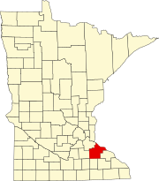
Belvidere Mills is an unincorporated community in Belvidere Township, Goodhue County, Minnesota, United States.
The community is located near the junction of County 2 Boulevard and County 3 Boulevard.
State Highway 58 (MN 58) and County Road 9 are also nearby. Wells Creek and Clear Creek both flow through the community.
Nearby places include Goodhue, Red Wing, Frontenac, Bellechester, and Lake City.
Belvidere Mills is located in sections 4 and 5 of Belvidere Township.
ZIP codes 55027 (Goodhue) and 55066 (Red Wing) meet near Belvidere Mills. The community had a post office from 1877 to 1905.
References
- "Belvidere Mills, Minnesota". Geographic Names Information System. United States Geological Survey, United States Department of the Interior.
| Municipalities and communities of Goodhue County, Minnesota, United States | ||
|---|---|---|
| County seat: Red Wing | ||
| Cities |  | |
| Townships | ||
| CDP | ||
| Unincorporated communities | ||
| Indian reservation | ||
| Ghost towns/Neighborhoods | ||
| Footnotes | ‡This populated place also has portions in an adjacent county or counties | |
This article about a location in Goodhue County, Minnesota is a stub. You can help Misplaced Pages by expanding it. |