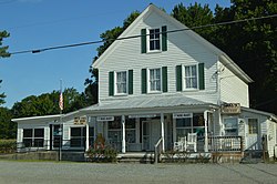
| Bena, Virginia | |
|---|---|
| Unincorporated community | |
 Post office Post office | |
  | |
| Coordinates: 37°16′16″N 76°27′20″W / 37.27111°N 76.45556°W / 37.27111; -76.45556 | |
| Country | United States |
| State | Virginia |
| County | Gloucester |
| Elevation | 7 ft (2 m) |
| Time zone | UTC-5 (Eastern (EST)) |
| • Summer (DST) | UTC-4 (EDT) |
| ZIP code | 23018 |
| Area code | 804 |
| GNIS feature ID | 1477108 |
Bena is an unincorporated community in Gloucester County, Virginia, United States. The community is located on Virginia State Route 216, 2.5 miles (4.0 km) east-northeast of Gloucester Point. Bena has a post office with ZIP code 23018.

The historic Little England plantation house is in the area and Bena was home to the Little England Daffodil Farm.
References
- U.S. Geological Survey Geographic Names Information System: Bena, Virginia
- "Free ZIP Code Lookup with area code, county, geocode, MSA/PMSA, population". www.zipinfo.com. Archived from the original on September 18, 2012.
- "Little England Daffodil Farm, Bena, Virginia, USA; 1950 – 1959". dafflibrary.org.
- "The Slow Decline". Daffodil Festival 24. September 13, 2022.
| Municipalities and communities of Gloucester County, Virginia, United States | ||
|---|---|---|
| County seat: Gloucester Courthouse | ||
| CDPs |  | |
| Unincorporated communities |
| |
| Ghost Town | ||
This Gloucester County, Virginia state location article is a stub. You can help Misplaced Pages by expanding it. |