Suburb of Cairns Region, Queensland, Australia
| Bentley Park Queensland | |||||||||||||||
|---|---|---|---|---|---|---|---|---|---|---|---|---|---|---|---|
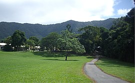
 View from Bentley Park, QLD with Fletcher Court and Lamb Range, QLD in background View from Bentley Park, QLD with Fletcher Court and Lamb Range, QLD in background | |||||||||||||||
 | |||||||||||||||
| Coordinates | 17°00′39″S 145°43′23″E / 17.0108°S 145.7230°E / -17.0108; 145.7230 (Bentley Park (centre of suburb)) | ||||||||||||||
| Population | 8,360 (2021 census) | ||||||||||||||
| • Density | 1,212/km (3,138/sq mi) | ||||||||||||||
| Postcode(s) | 4869 | ||||||||||||||
| Area | 6.9 km (2.7 sq mi) | ||||||||||||||
| Location |
| ||||||||||||||
| LGA(s) | Cairns Region | ||||||||||||||
| State electorate(s) | Mulgrave | ||||||||||||||
| Federal division(s) | Kennedy | ||||||||||||||
| |||||||||||||||
Bentley Park is a suburb of Cairns within the local government area of Cairns Region, Queensland, Australia. It is located approximately 9 km (6 mi) south of the Cairns City. In the 2021 census, Bentley Park had a population of 8,360 people.
History
Bentley Park is situated in the Yidinji traditional Aboriginal country. The origin of the suburb name is from a property titled Bentley Hall in England, named by an early settler Isaac Abraham Hartill.
The Edmonton Catholic School was established on 29 April 1929 by the Sisters of Mercy with an initial enrolment of 30 pupils. In 1965, it was renamed St Therese’s School. As suburban development increased around Edmonton, the rising number of students made it necessary to relocate the school to neighbouring Bentley Park in 1995. Although now under lay leadership, the school continues to be operated in the Mercy tradition.
Bentley Park State School was originally opened in 1997. In 2004, the construction of seconary school facilities made it a P-12 school called Bentley Park College.
Demographics
In the 2016 census, Bentley Park had a population of 7,420 people.
In the 2016 census, Bentley Park had a population of 8,018 people.
In the 2021 census, Bentley Park had a population of 8,360 people.
Education

St Therese's School is a Catholic primary (Prep-6) school for boys and girls at 135 Robert Road (17°00′23″S 145°43′52″E / 17.0064°S 145.7312°E / -17.0064; 145.7312 (St Therese's School)). In 2018, the school had an enrolment of 620 students with 41 teachers (38 full-time equivalent) and 30 non-teaching staff (19 full-time equivalent).
Bentley Park College is a government primary and secondary (Prep-12) school for boys and girls at McLaughlin Road (17°00′33″S 145°44′24″E / 17.0093°S 145.7400°E / -17.0093; 145.7400 (Bentley Park College)). In 2018, the school had an enrolment of 1541 students with 126 teachers (122 full-time equivalent) and 85 non-teaching staff (64 full-time equivalent). It includes a special education program.
Amenities
St Therese's Catholic Church is at 135 Robert Road. It is within the Edmonton Parish of the Roman Catholic Diocese of Cairns.
References
- ^ Australian Bureau of Statistics (28 June 2022). "Bentley Park (SAL)". 2021 Census QuickStats. Retrieved 28 February 2023.

- "Bentley Park (entry 45559)". Queensland Place Names. Queensland Government. Retrieved 15 April 2014.
- "First people cultural history". Cairns Regional Council. Archived from the original on 21 April 2017. Retrieved 23 June 2020.
- "Cairns Heritage: B Suburbs" (PDF). Cairns Regional Council. Archived from the original (PDF) on 22 April 2018. Retrieved 23 June 2020.
- Queensland Family History Society (2010), Queensland schools past and present (Version 1.01 ed.), Queensland Family History Society, ISBN 978-1-921171-26-0
- "Our History". St Therese's Catholic School, Bentley Park. Archived from the original on 18 November 2020. Retrieved 18 November 2020.
- "History". Bentley Park College. Archived from the original on 26 January 2014. Retrieved 16 April 2014.
- Australian Bureau of Statistics (31 October 2012). "Bentley Park". 2011 Census QuickStats. Retrieved 15 April 2014.

- Australian Bureau of Statistics (27 June 2017). "Bentley Park (State Suburb)". 2016 Census QuickStats. Retrieved 18 April 2018.

- ^ "State and non-state school details". Queensland Government. 9 July 2018. Archived from the original on 21 November 2018. Retrieved 21 November 2018.
- "St Therese's School". Retrieved 21 November 2018.
- ^ "ACARA School Profile 2018". Australian Curriculum, Assessment and Reporting Authority. Retrieved 28 January 2020.
- "Bentley Park College". Retrieved 21 November 2018.
- "Bentley Park College - Special Education Program". Retrieved 21 November 2018.
- "Edmonton Parish". Roman Catholic Diocese of Cairns. Archived from the original on 18 November 2020. Retrieved 18 November 2020.
External links
- "Bentley Park". Queensland Places. Centre for the Government of Queensland, University of Queensland.