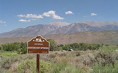
| Benton Hot Springs | |
|---|---|
 Benton Hot Springs Benton Hot Springs | |
| Location | Mono County, California |
| Coordinates | 37°48′01″N 118°31′44″W / 37.80028°N 118.52889°W / 37.80028; -118.52889 |
| Elevation | 5,630 feet (1,720 m) |
The Benton Hot Springs are in Mono County, California around which grew the town of Benton (also known as Old Benton, and Hot Springs). It is located 3 miles (4.8 km) west-southwest of Benton and 31 miles (50 km) north-northwest of Bishop, at an elevation of 5630 feet (1716 m). It is part of the Benton census-designated place for statistical purposes.
The Benton post office opened at the place in 1886. The name honors Senator Thomas Hart Benton, United States senator from Missouri. The town saw its heyday from 1862 to 1889 as a supply center for nearby mines. At the end of the 19th century, the town declined and the name Benton was transferred to Benton Station.
Of the springs at the site, one was described in a 1915 book as issuing water at 135 °F (57 °C).
Nearby
Other springs are located nearby: Paert's Hot Springs and Taylor Springs, a little more than 1 mile (1.6 km) northeast of Benton Hot Springs.
References
- ^ "Benton Hot Springs". Geographic Names Information System. United States Geological Survey, United States Department of the Interior.
- Waring 1915, p. 200.
- ^ Durham, David L. (1998). California's Geographic Names: A Gazetteer of Historic and Modern Names of the State. Clovis, Calif.: Word Dancer Press. p. 1146. ISBN 1-884995-14-4.
- "Benton, CA". TIGERweb. Geography Division, U.S. Census Bureau. Retrieved October 28, 2022.
- Waring 1915, p. 136.
Reference bibliography
- Waring, Gerald Ashley (1915). Springs of California. U.S. Geological Survey Water Supply Paper. Vol. 338. U.S. Government Printing Office. doi:10.3133/wsp338.
This Mono County, California-related article is a stub. You can help Misplaced Pages by expanding it. |