Town in Victoria, Australia
| Beulah Victoria | |||||||||
|---|---|---|---|---|---|---|---|---|---|
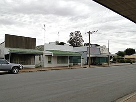
 Main street of Beulah, 2012 Main street of Beulah, 2012 | |||||||||
 | |||||||||
| Coordinates | 35°56′17″S 142°25′12″E / 35.93806°S 142.42000°E / -35.93806; 142.42000 | ||||||||
| Population | 329 (2016 census) | ||||||||
| Postcode(s) | 3395 | ||||||||
| Elevation | 100 m (328 ft) | ||||||||
| Location |
| ||||||||
| LGA(s) | Shire of Yarriambiack | ||||||||
| State electorate(s) | Mildura | ||||||||
| Federal division(s) | Mallee | ||||||||
| |||||||||
Beulah is a town in the southern Mallee region of Victoria, Australia. The town is in the Shire of Yarriambiack local government area, 395 kilometres north-west of the state capital, Melbourne. At the 2016 census, Beulah had a population of 329.
History
The town's name is taken from the Book of Isaiah, 62:4. In some English translations, the word is given as "married" or "inhabited".
Beulah was established on land that was once part of Brim station. Closer settlement began in the 1880s and the town site was proclaimed in 1891. A post office opened on May 6, 1891, and the railway from Warracknabeal opened on 5 January 1893. The line to Hopetoun opened on 6 March 1894. The town claims to be the closest to the rabbit-proof fence, established in the first decade of the 20th century to prevent the incursion of rabbit plagues.
Beulah was the location for the fictional town Kiewarra in the 2019 film The Dry, starring Eric Bana.
Climate
| Climate data for Beulah, elevation 89 m (292 ft) | |||||||||||||
|---|---|---|---|---|---|---|---|---|---|---|---|---|---|
| Month | Jan | Feb | Mar | Apr | May | Jun | Jul | Aug | Sep | Oct | Nov | Dec | Year |
| Record high °C (°F) | 46.7 (116.1) |
44.3 (111.7) |
40.4 (104.7) |
35.0 (95.0) |
27.8 (82.0) |
24.4 (75.9) |
26.5 (79.7) |
27.7 (81.9) |
34.2 (93.6) |
38.3 (100.9) |
42.2 (108.0) |
44.0 (111.2) |
46.7 (116.1) |
| Mean daily maximum °C (°F) | 30.9 (87.6) |
30.4 (86.7) |
27.2 (81.0) |
22.2 (72.0) |
17.6 (63.7) |
14.5 (58.1) |
13.9 (57.0) |
15.6 (60.1) |
18.6 (65.5) |
22.3 (72.1) |
26.1 (79.0) |
29.0 (84.2) |
22.4 (72.3) |
| Mean daily minimum °C (°F) | 13.7 (56.7) |
13.9 (57.0) |
11.7 (53.1) |
8.7 (47.7) |
6.3 (43.3) |
4.3 (39.7) |
3.6 (38.5) |
4.2 (39.6) |
5.6 (42.1) |
7.5 (45.5) |
9.9 (49.8) |
12.2 (54.0) |
8.5 (47.3) |
| Record low °C (°F) | 4.0 (39.2) |
6.7 (44.1) |
3.9 (39.0) |
1.1 (34.0) |
−2.1 (28.2) |
−3.9 (25.0) |
−3.2 (26.2) |
−2.8 (27.0) |
−0.9 (30.4) |
−1.7 (28.9) |
1.9 (35.4) |
3.9 (39.0) |
−3.9 (25.0) |
| Average rainfall mm (inches) | 22.5 (0.89) |
24.5 (0.96) |
21.2 (0.83) |
25.0 (0.98) |
38.1 (1.50) |
37.5 (1.48) |
36.0 (1.42) |
39.0 (1.54) |
37.6 (1.48) |
35.4 (1.39) |
28.9 (1.14) |
25.7 (1.01) |
371.2 (14.61) |
| Average rainy days (≥ 1.0 mm) | 2.4 | 2.3 | 2.7 | 3.9 | 5.8 | 6.6 | 7.6 | 7.7 | 6.7 | 5.6 | 4.1 | 3.3 | 58.7 |
| Source: Australian Bureau of Meteorology | |||||||||||||
References
- ^ Australian Bureau of Statistics (27 June 2017). "Beulah (State Suburb)". 2016 Census QuickStats. Retrieved 4 October 2018.

- "Beulah". Travel. Sydney Morning Herald. 8 February 2004. Retrieved 28 May 2007.
- Phoenix Auctions History. "Post Office List". Retrieved 28 January 2021.
- ^ "Hopteoun Line". Infrastructure. VICSIG. 2012. Retrieved 30 November 2012.
- "Beulah, Victoria". Travelmate. Retrieved 27 May 2007.
- "Drought, no pub and a burnt-down general store: Struggling town of 300 shines in major movie role". ABC News. 16 January 2021. Retrieved 13 September 2024.
- "Climate statistics for Australian locations- BEULAH". 8 July 2024.
External links
![]() Media related to Beulah, Victoria at Wikimedia Commons
Media related to Beulah, Victoria at Wikimedia Commons
- Official town website
- Yarriambiack Shire Council - Official council site
| Localities in the Shire of Yarriambiack | ||
|---|---|---|
| Town |  | |
| Locality | ||
| ^ - Territory divided with another LGA | ||
| Cities and towns in the Wimmera region of Victoria | |
|---|---|
| Cities: | |
| Towns: | |
| Localities: |
|
This article about a location in the Mallee is a stub. You can help Misplaced Pages by expanding it. |