| This article needs additional citations for verification. Please help improve this article by adding citations to reliable sources. Unsourced material may be challenged and removed. Find sources: "Bhairabkunda" – news · newspapers · books · scholar · JSTOR (February 2012) (Learn how and when to remove this message) |
| Bhairabkunda | |
|---|---|
| city | |
  | |
| Coordinates: 26°53′24″N 92°06′54″E / 26.8900°N 92.1150°E / 26.8900; 92.1150 | |
| Country | |
| State | Assam |
| District | Udalguri |
| Elevation | 703 m (2,306 ft) |
| Languages | |
| • Official | Bodo |
| Time zone | UTC+5:30 (IST / BST) |
| ISO 3166 code | IN-AS |
| Vehicle registration | AS |
Bhairabkunda is a popular picnic spot in Udalguri district in the State of Assam, India. It is situated on the border of Bhutan.
The Jampani River, originating in Bhutan, and Bhairabi River merge here to form Dhanshiri River. Dhanshiri river is a major tributary of Brahmaputra river. An irrigation project was constructed on Dhanshiri river at Bhairabkunda. A guide dam was constructed inside Bhutan for this project. The construction of the project took much more time than planned due to strong currents and terrorism. The Project is situated in Udalguri Districtt within jurisdiction of Bodoland Territorial Region (B.T.R.) aimed to provide assured irrigation to an area of 41.683 hectares (103.00 acres) in five development blocks viz. Udalguri, Rowta, Kalaigaon, Mazbat and Bechimari under Udalguri Civil Sub-Division.
Along with the irrigation project, a hydro-electric project was also planned to generate 20 MW of electricity out of 5 No. falls per 9 metres (30 ft) drop, but it did not materialise.
Geography
Bhairabkunda has an average elevation of 703 metres. It stands as one of the famous picnic spots in Assam. Both locals and tourists are drawn towards this place because of its location and features. One attraction of the place is that it shares border with Bhutan and stands as a suitable entrypoint to the country. People can also cross the international border on foot from here and visit the adjacent Daifam town. There is also a suspension bridge made with steel cables that connects Bhairabkunda with Daifam, which is a tourist destination, and a spot for photography.
Tourist Places
- Bhairabkunda Picnic Spot- Thousands of picnickers visit this place through November to early February.
- Bhairabkunda Shiva Mandir- Geographically located in Bhutan, but near Bhairabkunda town. Significant Number of devotees visit this place throughout the year. The number, however, increases during special occasions.
- Gethsemane Man-made Forest- A forest grown entirely by local JFMC of 35 members with the help of Forest department of Assam. Spread across more than 6 km. With more than 14 lakh plus trees of over 35 varieties. A number of animals, birds and reptiles can also be seen here. Visitors can also stay the night in their Guest house.
Bhairabkunda Tourism Festival
Bhairabkunda Tourism Festival is organised during the month of January every year. The event is organised in the bank of river Dhansiri and Bhairabkunda Tourism Complex. The main objective of this event is to promote tourism in the locality and to expose the vibrant local culture. The main attractions of this events are folk dance and music, traditional cuisines and traditional dresses shows from across the Northeast region as well as from Bhutan. Other activities in the event include elephant and Jeep safari as well.
-
 Dhansiri river in Bhairabkunda
-
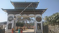
 Gate at India-Bhutan international border in Bhairabkunda
-
 Bhairabkunda picnic spot
-
 Gethsemane Man-made Forest
-
 Aerial View of Gethsemane Man-made Forest
-
 Gethsemane Man-made Forest
References
- Devi "Ecotourism in assam: A promising opportunity for development." South Asian Journal of Tourism and Heritage 5.1 (2012): 179-192., Meena Kumari (January 2012). "Ecotourism in assam: A promising opportunity for development" (PDF). South Asian Journal of Tourism and Heritage (2012). 5 (1): 188 – via Scholar.
{{cite journal}}: CS1 maint: numeric names: authors list (link) - ^ "Tourist Places | Udalguri District | Government of Assam, India". udalguri.assam.gov.in. Retrieved 20 September 2020.
- "Tourism heaven along the Himalayan foothills". www.telegraphindia.com. Retrieved 20 September 2020.
- ^ "Welcome to Udalguri District". udalguri.gov.in. Retrieved 20 September 2020.
- Talukdar, Sushanto. "The third Bodo accord: A new deal". Frontline. Retrieved 20 September 2020.
- "Afforestation changes life and landscape: How a district in Assam lost a forest, gained a future". The Indian Express. 25 December 2017. Retrieved 20 September 2020.
- "Once fighting for Bodoland, 35 men divert their efforts to grow a forest". Mongabay-India. 28 January 2020. Retrieved 20 September 2020.
- "Assam: Bhairabkunda Festival to be held from Jan 16". Times of India Travel. Retrieved 20 September 2020.
- "Bhairabkunda festival to start from Jan 16". Pratidin Time. 14 January 2020. Retrieved 20 September 2020.
Bhairabkunda Picnic Place Gethsemane Man-made Forest JFMC 1
Further reading
- Army celebrates International Day of Forests at 6 sq km manmade forest near Bhairabkunda. The Sentinel. 23 March 2019.
- "Barren forest land regenerated at Bhairabkunda". The Assam Tribune. 25 December 2011.
- "New tourist guest house at Bhairabkunda". Assam Times. 17 November 2014.
- "4th Bhairabkunda festival underway at Udalguri". The Eastern Today. 4 January 2016.
- "Govt urged to provide funds for man-made forest". The Assam Tribune. 20 July 2016.
- "Bhairabkunda calling you". Assam Times. 2 December 2016.
- "Community conservation initiative at Bhairabkunda". The Assam Tribune. 19 December 2016.
- "Flying Snakes of Gethsemane Forest. Gethsemane Man-made Forest. 26 May 2019.
- "Explore Bhairabkunda: 8 Things to See". Gethsemane Man-made Forest. 22 November 2018.