| Biała | |
|---|---|
| District | |
 | |
| Coordinates: 49°58′48″N 22°1′16″E / 49.98000°N 22.02111°E / 49.98000; 22.02111 | |
| Country | |
| Voivodeship | Subcarpathian |
| City | Rzeszów |
Biała (Ukrainian: Біла Bila) is a district of Rzeszów, Subcarpathian Voivodeship, in south-eastern Poland. It merged with Rzeszów on 1 January 2009.
The former village had a population of 1,300.
History
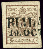
As a result of the first of Partitions of Poland (Treaty of St-Petersburg dated 5 July 1772, the Galicia area was attributed to the Habsburg Monarchy. BIALA was one of the 79 Bezirkshauptmannschaft (powiat?) in Austrian Galicia.
For more details, see the article Kingdom of Galicia and Lodomeria.

References
- "Central Statistical Office (GUS) - TERYT (National Register of Territorial Land Apportionment Journal)" (in Polish). 2008-06-01.
- Atlas des peuples d'Europe centrale, André et Jean Sellier, 1991, p.88
- Die postalischen Abstempelungen auf den österreichischen Postwertzeichen-Ausgaben 1867, 1883 und 1890, Wilhelm KLEIN, 1967