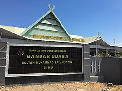
| Sultan Muhammad Salahuddin Airport Bandar Udara Sultan Muhammad Salahuddin | |||||||||||
|---|---|---|---|---|---|---|---|---|---|---|---|
 | |||||||||||
| Summary | |||||||||||
| Airport type | Public | ||||||||||
| Owner | Government of Indonesia | ||||||||||
| Operator | Ministry of Transportation | ||||||||||
| Serves | Bima, West Nusa Tenggara, Indonesia | ||||||||||
| Location | Sumbawa | ||||||||||
| Time zone | WITA (UTC+08:00) | ||||||||||
| Elevation AMSL | 3 ft / 1 m | ||||||||||
| Coordinates | 08°32′23″S 118°41′14″E / 8.53972°S 118.68722°E / -8.53972; 118.68722 | ||||||||||
| Website | bmu | ||||||||||
| Map | |||||||||||
  | |||||||||||
| Runways | |||||||||||
| |||||||||||
Sultan Muhammad Salahuddin Airport (IATA: BMU, ICAO: WADB), also known as Bima Airport, is a public airport located approximately 10 kilometres (6.2 mi) to the south of the city of Bima, on the island of Sumbawa, West Nusa Tenggara, Indonesia.
The airport was previously known as Palibelo Airport (IATA: PBW, ICAO: WRRB); however, that name was discontinued by IATA when the airport was renamed after Sultan Muhammad Salahuddin, the last king of the Bima Sultanate.
Airlines and destinations
| Airlines | Destinations |
|---|---|
| Wings Air | Denpasar, Ende, Lombok, Makassar |
Statistics
| Rank | Destinations | Frequency (weekly) | Airlines |
|---|---|---|---|
| 1 | Lombok | 21 | Citilink, Wings Air |
| 2 | Denpasar | 8 | Wings Air |
| 3 | Makassar | 5 | Wings Air |
References
- "Airport information for WADB - Muhammad Salahuddin Airport - Bima, Indonesia". World Aero Data. Archived from the original on 2019-03-05.
{{cite web}}: CS1 maint: unfit URL (link) Data current as of October 2006. - "IATA location code search page". IATA. October 21, 2012.
- "Wings Air Bakal Punya Rute Baru, Hubungkan Sumbawa dan Flores". travel.detik.com. Retrieved 24 July 2024.
- "LION AIR GROUP CARRIERS AUG 2024 INDONESIA NETWORK ADDITIONS". AeroRoutes. Retrieved 12 August 2024.
External links
| Airports in Indonesia (Statistics) | |||||||||||||||||||||||
|---|---|---|---|---|---|---|---|---|---|---|---|---|---|---|---|---|---|---|---|---|---|---|---|
| |||||||||||||||||||||||
| |||||||||||||||||||||||
| |||||||||||||||||||||||
| |||||||||||||||||||||||
| |||||||||||||||||||||||
| |||||||||||||||||||||||
| |||||||||||||||||||||||
| Names in bold are international airports; names of international airports marked with ‡ have Visa on Arrival (VoA) facility Names of airports marked with ⬠ are exclusively or also served as military airbase | |||||||||||||||||||||||
This West Nusa Tenggara location article is a stub. You can help Misplaced Pages by expanding it. |
This article about an Indonesian airport is a stub. You can help Misplaced Pages by expanding it. |