Human settlement in England
| Bingley | |
|---|---|
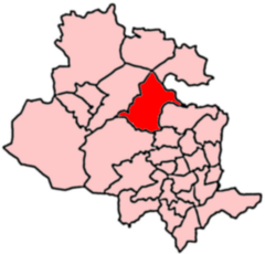
 2004 Boundaries of Bingley Ward 2004 Boundaries of Bingley Ward | |
 | |
| Population | 18,294 (2011 census) |
| OS grid reference | SE106394 |
| Metropolitan borough | |
| Metropolitan county | |
| Region | |
| Country | England |
| Sovereign state | United Kingdom |
| Post town | BRADFORD |
| Postcode district | BD16 |
| Dialling code | 01274 |
| Police | West Yorkshire |
| Fire | West Yorkshire |
| Ambulance | Yorkshire |
| UK Parliament | |
| Councillors |
|
| 53°51′03″N 1°50′17″W / 53.8509°N 1.8380°W / 53.8509; -1.8380 | |
Bingley (population 13,675 - 2001 UK census, 18,294 at the 2011 Census) is a Ward in Bradford Metropolitan District in the county of West Yorkshire, England, named after the town of Bingley around which it is centred.
As well as the town of Bingley the ward includes the conurbated villages of Eldwick, Gilstead, the slightly detached village of Micklethwaite and part of Crossflatts (the rest of which is located in Keighley East). The ward also extends to cover a substantial section of the moorland above the town.
References
- ^ UK Census (2011). "Local Area Report – Bingley Ward (as of 2011) (E05001342)". Nomis. Office for National Statistics. Retrieved 13 March 2022.
- UK Census (2001). "Local Area Report – Bingley Ward (00CXFB)". Nomis. Office for National Statistics. Retrieved 13 March 2022.
- "List of wards in Bradford District". www.bradford.gov.uk. Retrieved 13 March 2022.
External links
- BCSP (Internet Explorer only)
- BBC election results
- Council ward profile (pdf)
This West Yorkshire location article is a stub. You can help Misplaced Pages by expanding it. |