| This article needs additional citations for verification. Please help improve this article by adding citations to reliable sources. Unsourced material may be challenged and removed. Find sources: "Bismarck Range" – news · newspapers · books · scholar · JSTOR (January 2021) (Learn how and when to remove this message) |
| Bismarck Range | |
|---|---|
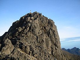
 Mount Wilhelm in the Bismarck Range Mount Wilhelm in the Bismarck Range | |
| Highest point | |
| Peak | Mount Wilhelm |
| Elevation | 4,509 m (14,793 ft) |
| Coordinates | 5°48′S 145°02′E / 5.800°S 145.033°E / -5.800; 145.033 |
| Geography | |
 | |
| Country | Papua New Guinea |
| Provinces | |
| Range coordinates | 5°30′S 144°45′E / 5.500°S 144.750°E / -5.500; 144.750 |
The Bismarck Range is a mountain range in the Western Highlands Province of Papua New Guinea. The range is named after the German Chancellor Otto von Bismarck.
The highest point of the range and the country is Mount Wilhelm at 4,509 metres (14,793 ft). At over 3,400 metres (11,155 ft), the landscape is alpine with tundra, in spite of the tropical climate. The Ramu River has its source in the range.
The Bismarck Forest Corridor, which bridges the provinces of Chimbu, Eastern Highlands, Jiwaka, and Madang, is located on the Bismarck Range. This corridor is an intact montane forest composed of Papua New Guinea oak and beech forest. The forest is a critical habitat for endangered species such as the Goodfellow's tree-kangaroo, giant rats, and many species of birds of paradise.

References
- "Bismarck Range, Papua New Guinea - Geographical Names, map, geographic coordinates". geographic.org. Retrieved 25 April 2024.
- "Bismarck Forest Corridor". png.wcs.org. Retrieved 25 April 2024.
This Papua New Guinea–related geography article is a stub. You can help Misplaced Pages by expanding it. |