| Siksika 146 | |
|---|---|
| Indian reserve | |
| Siksika Indian Reserve No. 146 | |
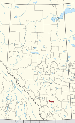
 Location in Alberta Location in Alberta | |
| First Nation | Siksika Nation |
| Country | Canada |
| Province | Alberta |
| Municipal districts | Vulcan Wheatland |
| Headquarters | Gleichen |
| Area | |
| • Land | 701.96 km (271.03 sq mi) |
| Population | |
| • Total | 3,576 |
| • Density | 4.96/km (12.8/sq mi) |
Siksika 146 is a First Nations reserve of the Siksika Nation in southern Alberta, Canada. It is 87 km (54 mi) southeast of Calgary at an elevation of 857 m (2,812 ft).
Geography
The locality of Siksika is on the Siksika 146 reserve. The reserve is bordered by Vulcan County, Wheatland County, and the County of Newell and is home to the Blackfoot Crossing historical park.
Demographics
In the Canada 2021 Census, Siksika 146 recorded a population of 3,576. The reserve has a land area of 696.54 km (268.94 sq mi), making it the second-largest Indigenous reserve in Canada (after Blood 148, Alberta).
References
- ^ "Census Profile, 2016 Census". Statistics Canada. February 8, 2017. Retrieved 2019-08-10.
- "Siksika 146". Statistics Canada. 2001. Retrieved 6 January 2010.
- Geo-Administrative Areas (Hamlet, Locality and Townsite Culture Points) (Geodatabase layer) (Map). AltaLIS. October 26, 2020. Retrieved October 2, 2021.
{{cite map}}: CS1 maint: date and year (link)
| Blackfoot Confederacy | ||||||
|---|---|---|---|---|---|---|
| Tribes or Nations |
|  | ||||
| Communities |
| |||||
| Culture | ||||||
| History |
| |||||
50°47′N 112°55′W / 50.783°N 112.917°W / 50.783; -112.917 (Siksika 146)
This Southern Alberta location article is a stub. You can help Misplaced Pages by expanding it. |
This article about an Indian reserve in Alberta is a stub. You can help Misplaced Pages by expanding it. |