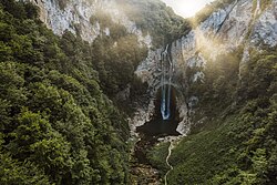
| Bliha Блиха | |
|---|---|
 Bliha Falls Bliha Falls | |
 | |
| Location | |
| Country | Bosnia and Herzegovina |
| Bosanska Krajina | Sanski Most |
| Physical characteristics | |
| Source | |
| • location | Donji Lipnik |
| • coordinates | 44°48′23″N 16°23′40″E / 44.806278°N 16.394323°E / 44.806278; 16.394323 |
| • elevation | ≈450 m (1,480 ft) |
| Mouth | |
| • location | Sana |
| • coordinates | 44°46′50″N 16°39′52″E / 44.780685350318734°N 16.664379724670287°E / 44.780685350318734; 16.664379724670287 |
| • elevation | 154 m (505 ft) |
| Length | 24 km (15 mi) |
| Basin features | |
| Progression | Sana→ Una→ Sava→ Danube→ Black Sea |
| Tributaries | |
| • left | Suvača, Obarak, Modrašnica, Hatiraj, Suhača |
| Waterfalls | Bliha Falls |
The Bliha (Serbian Cyrillic: Блиха) is a river in Bosnia and Herzegovina. It is a left tributary of the Sana river, located in region of Bosanska Krajina, on Sanski Most municipality territory and town vicinity.
Bliha Falls
Main article: Bliha FallsThe Bliha Falls (Bosnian: Vodopad Blihe; or Bosnian: Slapovi Blihe), called by locals Blihin Skok (English: Bliha's Jump or English: Leap of Bliha), is a waterfall on the Bliha river located near Fajtovci, 14 kilometers west of Sanski Most, Bosnia and Herzegovina. The 56 meters high waterfall is designated a natural monument since 1965.
See also
References
- "Sanski Most" (PDF) (in Bosnian). Government of Bosnia and Herzegovina. p. 2. Archived from the original (PDF) on 1 August 2014. Retrieved 15 July 2012.
- "Vodopad Bliha". European Environment Agency. Archived from the original on 11 November 2014. Retrieved 15 July 2012.
This Una-Sana Canton geography article is a stub. You can help Misplaced Pages by expanding it. |
