| Bogale Township ဘိုကလေးမြို့နယ်Bogalay Township | |
|---|---|
| Township | |
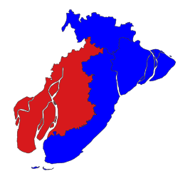
 Location in Pyapon district Location in Pyapon district | |
 | |
| Coordinates: 16°05′N 95°24′E / 16.083°N 95.400°E / 16.083; 95.400 | |
| Country | |
| Region | Ayeyarwady Region |
| District | Pyapon District |
| Administrative seat | Bogale |
| Population | 349,427 |
| Time zone | UTC+6:30 (MST) |
Bogale Township (Burmese: ဘိုကလေးမြို့နယ် [bòɡəlé mjo̰nɛ̀]) is a township of Pyapon District in the Ayeyarwady Region of Burma (Myanmar).
In May 2008, the town of Bogale suffered heavily from Cyclone Nargis; 36,325 people were listed as dead or missing.
Communities
On 8 August 2008, two village tracts (Kadonkani and Ayeyar) from Pyapon Township were moved into Bogale Township. As of March 2009, there were 71 village tracts comprising 589 villages in Bogale Township. Additional boundary adjustments were made on 5 August 2009.
Notes
- ^ "Bogale Township Profile" Myanmar Information Management Unit (MIMU) March 2009
External links
- "Bogale Township, Ayeyarwady Division" map ID: MIMU154v02, created: 1 July 2010, Myanmar Information Management Unit (MIMU)
- "Bogale Google Satellite Map" Maplandia World Gazetteer
This Ayeyarwady Region location article is a stub. You can help Misplaced Pages by expanding it. |
