| Bolikhamsai province ແຂວງ ບໍລິຄໍາໄຊ | |
|---|---|
| Province | |
 | |
 Map of Bolikhamsai province Map of Bolikhamsai province | |
 Location of Bolikhamsai province in Laos Location of Bolikhamsai province in Laos | |
| Coordinates: 18°23′00″N 103°39′00″E / 18.383333°N 103.65°E / 18.383333; 103.65 | |
| Country | Laos |
| Capital | Paksan |
| Area | |
| • Total | 14,863 km (5,739 sq mi) |
| Population | |
| • Total | 315,956 |
| • Density | 21/km (55/sq mi) |
| Time zone | UTC+7 (ICT) |
| ISO 3166 code | LA-BL |
| HDI (2017) | medium · 4th |
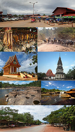
Bolikhamsai (also Borikhamxay, Lao: ບໍລິຄໍາໄຊ, pronounced [bɔ̀ː.lī(ʔ) kʰám.sáj]) is a province of Laos. Pakxan, Thaphabat, Pakkading, Borikhane, Viengthong, and Khamkeut are its districts and Pakxan is its capital city. The province is the site of the Nam Theun 2 Dam, the country's largest hydroelectric project.
Bolikhamsai province covers an area of 14,863 square kilometres (5,739 sq mi). Bolikhansai province borders Xiangkhouang province to the northwest, Vietnam to the east, Khammouane province to the south, and Thailand to the west. The province includes the Annamite Range, stretching east to Vietnam, while to the west are the Mekong River and Thailand. At 3,700 square kilometres (1,400 sq mi), the Nakai-Nam Theun National Park in Bolikhamsai and Khammouane provinces is the third largest protected area in Laos.
History
The province faced invasions from the Siamese throughout its history. The foundation of Paksan dates from the late nineteenth century. In 1836, the Siamese assumed suzerainty over Laos. After 1865, the invasions of "Hos", Chinese gangs from southern China, affected the provinces of Xieng Khouang and Bolikhamsai (Borikhane). In 1876, the King of Siam, Rama V, ordered the creation of the Muong Borikhane with the last survivors of the Ho invasion of 1874. The Muong of Borikhane was placed under the authority of Governor of Nong Khai.
In the 1890s, Christian missionaries of the Missions étrangères de Paris arrived on the Mekong River, a few miles from the mouth of the Nam Sane. They built a church at Paksan. By 1911, the Muong Borikhane had about 61 villages housing a population of about 4000 inhabitants. Paksane had grown to several thousand in 1937.
The modern province was formed in 1986 from parts of the Vientiane province and Khammuan. In recent times, religious tension has been apparent in the province. In February 2005, 100 villagers were forced to sell their possessions and prepare to be evicted in Kok Poh village in Borikham District, but the central authorities intervened to stop this.
Geography
Bolikhamsai province covers an area of 14,863 square kilometres (5,739 sq mi). Bolikhamsai province borders Xiangkhouang province to the northwest, Vietnam to the east, Khammouane province to the south, and Thailand to the west. Notable settlements include Pakxan, Borikham, Lak Sao, Muang Bo, Ban Hatkham, Ban Thana, Ban Thasi, Ban Hai, Ban Don, Ban Soppanga, Ban Pak Ham, Ban Naxon, Ban Kengbit, Ban Pakha, Ban Phayat, Ban Sopchat, Ban Muangcham and Ban Nap. The province includes the Annamite Range, stretching east to Vietnam, while to the west are the Mekong River and Thailand.
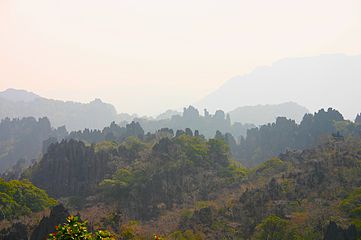
Bolikhamsai province has a rugged terrain, with large boulders and streams. Its elevation ranges from 140–1,588 metres (459–5,210 ft). The principal river is the Nam Kading, meaning 'water like a bell', a tributary of the Mekong; its catchment covers about 92% of the provincial area. The other main rivers are the Nam Muan, Nam Sat, and the Nam Tek. Waterfalls of note include the Tad Leuk, Tad Xay and Tad Xang. The longest mountain range in the province is the Phou Louang range, running to the southwest, the Phou Ao range to the southeast; the Thalabat range to the northwest, and the Pa Guang range to the northeast. In Khamkheuth District, there is karst limestone scenery, which is allegedly the largest formation of its type in Southeast Asia. The many rock pinnacles have formed stone forest similar to limestone outcrops in southern China.
-
 Karst rock formations
-
 Tad Leuk, Phou Khao Khouay National Protected Area
-
 Landscape, Lak Sao
-
Saola (Pseudoryx nghetinhensis)
Protected areas
At 4,270 square kilometres (1,650 sq mi), Nakai-Nam Theun National Park in Bolikhamsai and Khammouane provinces is the third largest protected area in Laos. It includes mixed semi-tropical forests, reported in large areas of Indochina. The wetlands of the Nam Kading National Protected Area and the Phou Khao Khouay National Protected Area attract numerous migratory birds, and also has some 13 globally and 12 regionally endangered mammals such as the Asiatic black bear, clouded leopard, elephant, giant muntjac, gaur, sun bear, and tiger and both northern and southern white-cheeked crested gibbon. The saola (spindle horn) or Vii Quang ox (Pseudoryx nghetinhensis) was discovered in neighbouring Vietnam in 1992 and sighted since then in this conservation area. In 1996, the saola was discovered living in the adjoining Khammouane province.
Under the World Wildlife Fund (WWF) Greater Mekong Lao PDR Country Programme, studies have been carried out in the two forest areas in the province to assess the degree of sustainable rattan harvest and production as it provides significant income in whole of the Mekong region to rural villages. The forest areas covered are 349 ha of forest area in Ban Soupphouan (Nong Kan and Phu Sangnoy villages) and 364 ha in Phonthong. The species sampled were mak naeng (cardamom), bamboo shoots of many species, all year san (Lao lady palm), mushrooms, pak van, kha (galangal), wai houn (Calamus melanochaetes, syn. Daemonorops jenkinsiana, rattan), phak kout (vegetable fern), wai khom (C. viminalis rattan), ya houa and ka don nam.
Mammals include tigers, Malayan sun bears, guars, giant muntjacs, elephants, clouded leopards, and Asiatic black bears. The mammal species protected under the Nam Kading National Protected Area are four critically endangered and endangered primate species: northern white-cheeked gibbons, southern white-cheeked gibbons, red-shanked douc langurs and two leaf-monkey species. Bird species recorded in the province are bulbuls such as the bare-faced bulbul (Pycnonotus hualon), thrushes and the green cochoa (Cochoa viridis). Four species of hornbills are also reported.
Administrative divisions
The province is made up of the following districts:
| Map | Code | Name | Lao script |
|---|---|---|---|

| |||
| 11–01 | Pakxan District | ເມືອງປາກຊັນ | |
| 11–02 | Thaphabat District | ເມືອງທ່າພະບາດ | |
| 11–03 | Pakkading District | ເມືອງປາກກະດິງ | |
| 11–04 | Borikhane District | ເມືອງບໍລິຄັນ | |
| 11–05 | Khamkeut District | ເມືອງຄຳເກີດ | |
| 11–06 | Viengthong District | ເມືອງວຽງທອງ | |
| 11–07 | Xaichamphon District | ເມືອງໄຊຈໍາພອນ |
Economy
Laos's largest hydroelectric project, Nam Theun 2 Dam (NT2), began operation in March 2010. The scheme diverts water from the Nam Theun, a tributary of the Mekong River, to the Xe Bang Fai River, enabling a generation capacity of 1,070 MW, from a 350 m (1,148 ft) difference in elevation between the reservoir and the power station. At the time of signing in 2005, NT2 was the largest foreign investment in Laos, the world's largest private sector cross-border power project financing, the largest private sector hydroelectric project financing, and one of the largest internationally financed IPP projects in Southeast Asia. The dam also marked a return by the World Bank to funding large-scale infrastructure, after a decade-long hiatus. The dam exports energy to neighboring Thailand, thus is important to the regional economy. Along with Khammouane and Savannakhet provinces, it is one of the main tobacco producing areas of Laos, and also one of the main producers of sugar cane and oranges.
Landmarks
Wat Phabath and Wat Phonsanh temples are important pilgrimage centres between Vientiane and Pakxan. Wat Phabath is said to have a very large footprint of Buddha and numerous murals. The location provides vistas of the Mekong River. Lak Sao, on the border, has the Nampao Checkpoint, crossing into Vietnam.
References
- "Sub-national HDI - Area Database - Global Data Lab". hdi.globaldatalab.org. Retrieved 2018-09-13.
- ^ "Destination: Borikhamxay Province". Laos Tourism Organization. Archived from the original on 13 October 2013. Retrieved 1 December 2012.
- ^ Ray 2009, p. 321.
- "Home". Regions. Official website of Laos Tourism. Archived from the original on 11 January 2013. Retrieved 7 January 2013.
- Brow 1976, p. 48.
- Sachs 1997, p. 18.
- Marshall 2007, p. 253.
- "Borikhamxay Province". Lao Tourism. Archived from the original on 13 October 2013. Retrieved 1 December 2012.
- ^ The Lao National Tourism Administration. "Bolikhamxay Province". Ecotourism Laos. GMS Sustainable Tourism Development Project in Lao PDR. Archived from the original on 29 August 2012. Retrieved 1 December 2012.
- "Lao PDR's Nakai Nam Theun National Park to join leading protected areas in Southeast Asia, nominated to IUCN's Green List". IUCN. 18 August 2020. Retrieved 2 February 2021.
- ^ "Improved management of the Nam Kading National Protected Area of Bolikhamxay Province, Lao PDR". CBD Protected Areas. Retrieved 30 November 2012.
- ^ Campbell, Roderick (June 2009). "Technical Report Non Timber Forest Product inventory and value in Bolikhamsai Province, Lao PDR" (pdf). Lao Agriculture Database. National Agriculture and Forestry Research Institute. Retrieved 30 November 2012.
- "Bolikhamsai Province". Internet Bird Collection (IBC). Retrieved 29 November 2012.
- Lao People's Democratic Republic: Second Poverty Reduction Strategy Paper (EPub). International Monetary Fund. 21 October 2008. p. 54. ISBN 978-1-4527-9182-1. Retrieved 6 December 2012.
Sources
- Brow, James (1976). Population, Land and Structural Change in Sri Lanka and Thailand. Brill Archive. ISBN 978-90-04-04529-3.
- Great Britain. Parliament. House of Commons (1958). Papers by command. HMSO. p. 98.
- Leo, Leonard. International Religious Freedom (2010): Annual Report to Congress. DIANE Publishing. ISBN 978-1-4379-4439-6.
- Marshall, Paul A. (28 December 2007). Religious freedom in the world. Rowman & Littlefield Publishers. ISBN 978-0-7425-6212-7.
- Ray, Nick (11 September 2009). Lonely Planet Vietnam Cambodia Laos & the Greater Mekong. Lonely Planet. pp. 321–. ISBN 978-1-74179-174-7.
- Sachs, Carolyn E. (1997). Women Working in the Environment: Resourceful Natures. Taylor & Francis. pp. 18–. ISBN 978-1-56032-629-8.
| Places adjacent to Bolikhamsai province | |
|---|---|
| Subdivisions of Laos | ||
|---|---|---|
| Prefecture | ||
| Province | ||
| Districts of Central Laos | |
|---|---|
| Vientiane Prefecture | |
| Bolikhamsai province | |
| Vientiane province | |
| Xaisomboun province | |
| denotes provincial seat. | |