| Box Elder Creek | |
|---|---|
 The creek as it passes under Interstate 76 The creek as it passes under Interstate 76 | |
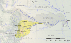
 South Platte tributaries, including Box Elder Creek South Platte tributaries, including Box Elder Creek | |
| Physical characteristics | |
| Source | |
| • coordinates | 39°30′06″N 104°33′40″W / 39.50167°N 104.56111°W / 39.50167; -104.56111 |
| Mouth | |
| • location | Confluence with the South Platte |
| • coordinates | 40°22′28″N 104°28′02″W / 40.37444°N 104.46722°W / 40.37444; -104.46722 |
| • elevation | 4,554 ft (1,388 m) |
| Basin features | |
| Progression | South Platte—Platte— Missouri—Mississippi |
Box Elder Creek is a tributary that joins the South Platte River near Kersey, Colorado. It rises in Elbert County, Colorado.
The creek flows through Elbert, Arapahoe, Adams, and Weld counties. It passes near Denver International Airport.
It was the site of the Hungate massacre which had a family of four murdered.
See also
References
- "Box Elder Creek". Geographic Names Information System. United States Geological Survey, United States Department of the Interior. Retrieved 2015-04-25.
- Robinson, Charles M.; Michno, Gregory F. (2005-04-01). "Encyclopedia of Indian Wars: Western Battles and Skirmishes, 1850-1890". The Western Historical Quarterly. 36 (1): 77. doi:10.2307/25443109. ISSN 0043-3810. JSTOR 25443109.
This article related to a river in Colorado is a stub. You can help Misplaced Pages by expanding it. |